
Keurboomsriver Nature Reserve topographic map
Interactive map
Click on the map to display elevation.
About this map
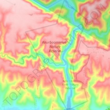
Name: Keurboomsriver Nature Reserve topographic map, elevation, terrain.
Average elevation: 144 m
Minimum elevation: -1 m
Maximum elevation: 240 m
Other topographic maps
Click on a map to view its topography, its elevation and its terrain.
Plettenberg Bay
South Africa > Western Cape > Garden Route District Municipality > Bitou Local Municipality
Plettenberg Bay, Bitou Local Municipality, Garden Route District Municipality, Western Cape, 6600, South Africa
Average elevation: 47 m
Keurboomstrand
South Africa > Western Cape > Garden Route District Municipality > Bitou Local Municipality
Keurboomstrand, Bitou Local Municipality, Garden Route District Municipality, Western Cape, South Africa
Average elevation: 84 m