
Make a donation
Cuando Cubango Province topographic map
Click on the map to display elevation.
Make a donation
About this map
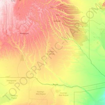
Name: Cuando Cubango Province topographic map, elevation, terrain.
Location: Cuando Cubango Province, Angola (-18.03938 16.46068 -13.56580 23.43405)
Average elevation: 1,201 m
Minimum elevation: 957 m
Maximum elevation: 1,864 m
Make a donation
Other topographic maps
Click on a map to view its topography, its elevation and its terrain.
Saurimo
Saurimo is located in northeastern Angola at an elevation of 1,084 m (3,556 ft) above sea level. It is a garrison town and local market center.
Average elevation: 1,066 m
Cuito
The town sits on the eastern flank of the Bie Plateau. The climate is unusually cool for its tropical location. The average annual temperature is 18 °C, largely due to its high altitude. The coolest period is May to August when almost no rain falls. September and October are the hottest months with a little…
Average elevation: 1,671 m
Make a donation
Make a donation
Make a donation