
Peren topographic map
Interactive map
Click on the map to display elevation.
About this map
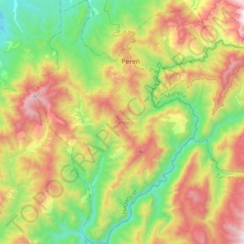
Name: Peren topographic map, elevation, terrain.
Location: Peren, Nagaland, 797101, India (25.35680 93.62935 25.60155 93.83041)
Average elevation: 1,030 m
Minimum elevation: 293 m
Maximum elevation: 2,197 m
Other topographic maps
Click on a map to view its topography, its elevation and its terrain.
Chiephobozou
India > Nagaland > Chiephobozou
Chiephobozou, Kohima District, Nagaland, 797105, India
Average elevation: 1,189 m
Kanubari
India > Nagaland > Mon District
Kanubari, Hunta, Mon District, Nagaland, India
Average elevation: 154 m
Sechu Zubza
India > Nagaland > Sechu-Zubza > Sechu Zubza
Sechu Zubza, Sechu-Zubza, Kohima, Nagaland, 797002, India
Average elevation: 1,004 m
Mokokchung
India > Nagaland > ONGPANGKONG (N)
Mokokchung, ONGPANGKONG (N), Mokokchung, Nagaland, 798601, India
Average elevation: 1,027 m
Kohima
India > Nagaland > Kohima Sadar
Kohima, Kohima Sadar, Kohima, Nagaland, 797001, India
Average elevation: 1,425 m
Dimapur
India > Nagaland > Dimapur Sadar
Dimapur, Dimapur Sadar, Dimapur, Nagaland, 797112, India
Average elevation: 204 m
Kigwema Town
India > Nagaland > Jakhama > Kigwema Town
Kigwema Town, Jakhama, Kohima, Nagaland, 797005, India
Average elevation: 1,688 m
Kiphire
India > Nagaland > Kiphire Sadar
Kiphire, Kiphire Sadar, Kiphire, Nagaland, 798611, India
Average elevation: 990 m
Doyang HEP Dam
Doyang HEP Dam, Englan, Wokha, Nagaland, India
Average elevation: 365 m