
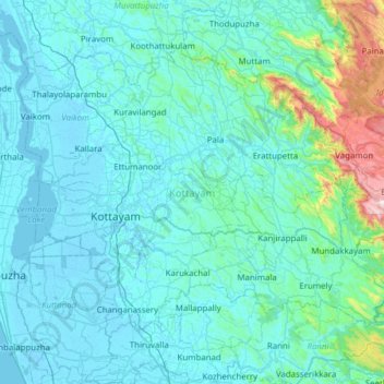
Kottayam topographic map
Interactive map
Click on the map to display elevation.
About this map
Name: Kottayam topographic map, elevation, terrain.
Location: Kottayam, Kerala, India (9.40026 76.36565 9.85729 76.98451)
Average elevation: 124 m
Minimum elevation: -6 m
Maximum elevation: 1,397 m
Other topographic maps
Click on a map to view its topography, its elevation and its terrain.
Kannur
Kannur has an elevation of 1.02 metres or 3.3 feet along the coast of the Laccadive Sea, with a sandy coastal area. The city has an 8 kilometres (5.0 miles)-long seashore and a 3 kilometres (1.9 miles)-long beach at Payyambalam. Kannur is located north of Kozhikode, south of Kasargod and Mangalore, west of the…
Average elevation: 14 m
Thiruvananthapuram
India > Kerala > Thiruvananthapuram
Thiruvananthapuram is built on seven hills by the seashore and is at 8°30′N 76°54′E / 8.5°N 76.9°E / 8.5; 76.9 on the west coast, near the southern tip of mainland India. The city is on the west coast of India and is bounded by the Laccadive Sea to its west and the Western Ghats to its east.…
Average elevation: 33 m
Thrissur
Thrissur is the headquarters of Thrissur district, in the center of the Indian state of Kerala. The city is 75 km north-east of Kochi, 133 km south-west of Coimbatore, 124 km south-east of Kozhikode and 151 km north of Changanacherry. The city is located in a hillock called Thekkinkadu Maidan which is the…
Average elevation: 36 m
Kollam
Cosmas Indicopleustes, a Greek Nestorian sailor, in his book the Christian Topography who visited the Malabar Coast in 550, mentions an enclave of Christian believers in Male (Malabar Coast). He writes, "In the island of Tabropane (Ceylon), there is a church of Christians, and clerics and faithful. Likewise at…
Average elevation: 12 m