
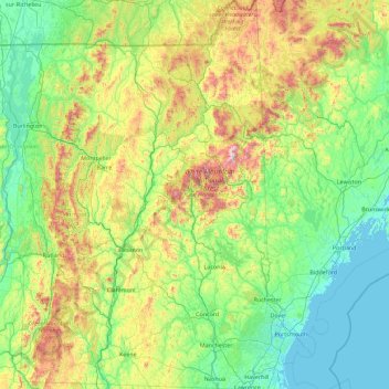
New Hampshire topographic map
Interactive map
Click on the map to display elevation.
About this map
Name: New Hampshire topographic map, elevation, terrain.
Location: New Hampshire, United States (42.69723 -72.55724 45.30578 -70.56136)
Average elevation: 293 m
Minimum elevation: -4 m
Maximum elevation: 1,693 m
Average daytime highs are in the mid 70s°F to low 80s°F (24–28 °C) throughout the state in July, with overnight lows in the mid 50s°F to low 60s°F (13–15 °C). January temperatures range from an average high of 34 °F (1 °C) on the coast to overnight lows below 0 °F (−18 °C) in the far north and at high elevations. Average annual precipitation statewide is roughly 40 inches (100 cm) with some variation occurring in the White Mountains due to differences in elevation and annual snowfall. New Hampshire's highest recorded temperature was 106 °F (41 °C) in Nashua on July 4, 1911, while the lowest recorded temperature was −47 °F (−44 °C) atop Mount Washington on January 29, 1934. Mount Washington also saw an unofficial −50 °F (−46 °C) reading on January 22, 1885, which, if made official, would tie the record low for New England (also −50 °F (−46 °C) at Big Black River, Maine, on January 16, 2009, and Bloomfield, Vermont on December 30, 1933).
Other topographic maps
Click on a map to view its topography, its elevation and its terrain.
Los Angeles
Los Angeles, Los Angeles County, California, United States
Average elevation: 241 m
New Orleans
United States > Louisiana > Orleans Parish
New Orleans, Orleans Parish, Louisiana, United States
Average elevation: 1 m
Houston
United States > Texas > Harris County
Houston, Harris County, Texas, United States
Average elevation: 25 m
Brooklyn
United States > New York > New York
Brooklyn, Kings County, New York, United States
Average elevation: 9 m
Jacksonville
United States > Florida > Duval County
Jacksonville, Duval County, Florida, United States
Average elevation: 10 m
Fort Worth
United States > Texas > Tarrant County
Fort Worth, Tarrant County, Texas, United States
Average elevation: 212 m
Montgomery County
Montgomery County, Texas, United States
Average elevation: 69 m
Honolulu
United States > Hawaii > Honolulu County
Honolulu, Honolulu County, Hawaii, United States
Average elevation: 90 m
Boulder
United States > Colorado > Boulder County
Boulder, Boulder County, Colorado, United States
Average elevation: 1,785 m
Knoxville
United States > Tennessee > Knox County
Knoxville, Knox County, East Tennessee, Tennessee, United States
Average elevation: 307 m
Fairfax County
Fairfax County, Virginia, United States
Average elevation: 75 m
Rancho Palos Verdes
United States > California > Los Angeles County
Rancho Palos Verdes, Los Angeles County, California, 90274, United States
Average elevation: 52 m
Des Moines
United States > Iowa > Polk County
Des Moines, Polk County, Iowa, United States
Average elevation: 264 m
Norfolk
United States > Virginia > Norfolk
Norfolk, Virginia, 23510, United States
Average elevation: 4 m
Redondo Beach
United States > California > Los Angeles County
Redondo Beach, Los Angeles County, California, 90278, United States
Average elevation: 19 m
Queens County
United States > New York > New York
Queens County, New York, United States
Average elevation: 11 m
Corpus Christi
United States > Texas > Nueces County
Corpus Christi, Nueces County, Texas, United States
Average elevation: 8 m
Santa Fe
United States > New Mexico > Santa Fe County
Santa Fe, Santa Fe County, New Mexico, United States
Average elevation: 2,221 m