
South Dakota topographic map
Interactive map
Click on the map to display elevation.
About this map
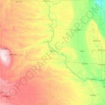
Name: South Dakota topographic map, elevation, terrain.
Location: South Dakota, United States (42.47989 -104.05776 45.94545 -96.43634)
Average elevation: 717 m
Minimum elevation: 274 m
Maximum elevation: 2,166 m
Black Elk Peak, formerly named Harney Peak, with an elevation of 7,242 ft (2,207 m), is the state's highest point, while the shoreline of Big Stone Lake is the lowest, with an elevation of 966 ft (294 m). South Dakota is bordered to the north by North Dakota; to the south by Nebraska; to the east by Iowa and Minnesota; and to the west by Wyoming and Montana. The geographical center of the U.S. is 17 miles (27 km) west of Castle Rock in Butte County. The North American continental pole of inaccessibility is between Allen and Kyle, 1,024 mi (1,648 km) from the nearest coastline.
Other topographic maps
Click on a map to view its topography, its elevation and its terrain.
Lot
United States > Kentucky > Whitley County
Lot, Whitley County, Kentucky, 37762, United States
Average elevation: 319 m
Lord
United States > Texas > Ochiltree County
Lord, Ochiltree County, Texas, United States
Average elevation: 908 m
Three Sisters
United States > Arizona > Navajo County
Three Sisters, Navajo County, Arizona, United States
Average elevation: 1,664 m
Village of Greenwood Lake
United States > New York > Orange County > Town of Warwick
Village of Greenwood Lake, Town of Warwick, Orange County, New York, 10925, United States
Average elevation: 272 m
Blowing Rock
United States > North Carolina > Watauga County
Blowing Rock, Watauga County, North Carolina, 28605, United States
Average elevation: 1,032 m
Mitchell Plain
United States > Indiana > Washington County
Mitchell Plain, Washington County, Indiana, 47120, United States
Average elevation: 205 m
Oakland
United States > California > Alameda County
Oakland, Alameda County, California, United States
Average elevation: 51 m
Hogsback
United States > New York > Onondaga County
Hogsback, Onondaga County, New York, 13063, United States
Average elevation: 411 m
Soul City
United States > North Carolina > Warren County
Soul City, Warren County, North Carolina, 27570, United States
Average elevation: 115 m
Red Hill
United States > South Carolina > Horry County > Conway
Red Hill, Conway, Horry County, South Carolina, United States
Average elevation: 9 m
Westbrook
United States > Texas > Mitchell County
Westbrook, Mitchell County, Texas, 79565, United States
Average elevation: 657 m
Rohnert Park
United States > California > Sonoma County
Rohnert Park, Sonoma County, California, United States
Average elevation: 39 m
Clifton
United States > New Jersey > Passaic County
Clifton, Passaic County, New Jersey, United States
Average elevation: 56 m
Yellowstone County
Yellowstone County, Montana, United States
Average elevation: 1,067 m
Sevierville
United States > Tennessee > Sevier County
Sevierville, Sevier County, East Tennessee, Tennessee, United States
Average elevation: 313 m
Siloam
United States > New Jersey > Monmouth County > Freehold Township
Siloam, Freehold Township, Monmouth County, New Jersey, United States
Average elevation: 44 m
Amherst County
Amherst County, Virginia, United States
Average elevation: 329 m
Chantilly
United States > Virginia > Fairfax County
Chantilly, Fairfax County, Virginia, United States
Average elevation: 96 m
Shanty Town
United States > Minnesota > Olmsted County
Shanty Town, Olmsted County, Minnesota, United States
Average elevation: 353 m
Loch Sheldrake
United States > New York > Sullivan County
Loch Sheldrake, Town of Fallsburg, Sullivan County, New York, United States
Average elevation: 448 m
Kyles
United States > Ohio > Butler County
Kyles, Liberty Township, Butler County, Ohio, 45050, United States
Average elevation: 222 m
Barrington
United States > Rhode Island > Bristol County
Barrington, Bristol County, Rhode Island, 02806, United States
Average elevation: 4 m
Pasco
United States > Washington > Franklin County
Pasco, Franklin County, Washington, 99301, United States
Average elevation: 141 m
Parsippany-Troy Hills
United States > New Jersey > Morris County
Parsippany-Troy Hills, Morris County, New Jersey, United States
Average elevation: 113 m
Rosedale
United States > California > Kern County
Rosedale, Kern County, California, United States
Average elevation: 113 m
Black Rock
United States > Arkansas > Lawrence County
Black Rock, Lawrence County, Arkansas, 72415, United States
Average elevation: 90 m
Trussville Manor
United States > Alabama > Jefferson County > Trussville
Trussville Manor, Trussville, Jefferson County, Alabama, 35173, United States
Average elevation: 237 m
Redoubt
United States > Alaska > Anchorage
Redoubt, Anchorage, Alaska, United States
Average elevation: 49 m
Flagstaff
United States > Arizona > Coconino County
Flagstaff, Coconino County, Arizona, United States
Average elevation: 2,176 m
Campbell County
Campbell County, Kentucky, United States
Average elevation: 223 m
Village of Clayville
United States > New York > Oneida County
Village of Clayville, Town of Paris, Oneida County, New York, United States
Average elevation: 361 m
Athens-Clarke County Unified Government
United States > Georgia > Athens-Clarke County
Athens-Clarke County Unified Government, Athens-Clarke County, Georgia, United States
Average elevation: 219 m
Fife Lake
United States > Michigan > Grand Traverse County
Fife Lake, Fife Lake Township, Grand Traverse County, Michigan, United States
Average elevation: 317 m
Riverbanks
United States > South Carolina > Richland County > Columbia
Riverbanks, Columbia, Richland County, South Carolina, 29202, United States
Average elevation: 69 m
Laurel
United States > Maryland > Prince George's County
Laurel, Prince George's County, Maryland, 20707, United States
Average elevation: 62 m
Austin
United States > Texas > Travis County
Austin, Travis County, Texas, United States
Average elevation: 216 m
Charlottesville
Charlottesville, Virginia, 22902, United States
Average elevation: 173 m
Kingsport
United States > Tennessee > Sullivan County
Kingsport, Sullivan County, East Tennessee, Tennessee, United States
Average elevation: 453 m
Codell
United States > Kansas > Rooks County
Codell, Rooks County, Kansas, United States
Average elevation: 620 m
Eliot
United States > Maine > York County
Eliot, York County, Maine, 03903, United States
Average elevation: 17 m
Seattle
United States > Washington > King County
Seattle, King County, Washington, United States
Average elevation: 40 m
Cherokee County
United States > North Carolina
Cherokee County, North Carolina, United States
Average elevation: 655 m
Pittsburgh
United States > Pennsylvania > Allegheny County
Pittsburgh, Allegheny County, Pennsylvania, United States
Average elevation: 303 m