
Thank you for supporting this site ❤️
Make a donation
Make a donation
Extertal topographic map
Click on the map to display elevation.
Thank you for supporting this site ❤️
Make a donation
Make a donation
About this map
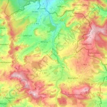
Name: Extertal topographic map, elevation, terrain.
Location: Extertal, Kreis Lippe, Noordrijn-Westfalen, 32699, Duitsland (52.03722 9.01949 52.14970 9.19403)
Average elevation: 228 m
Minimum elevation: 79 m
Maximum elevation: 389 m
Thank you for supporting this site ❤️
Make a donation
Make a donation
Other topographic maps
Click on a map to view its topography, its elevation and its terrain.