
Licking River topographic map
Interactive map
Click on the map to display elevation.
About this map
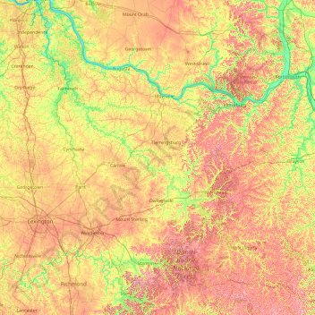
Name: Licking River topographic map, elevation, terrain.
Location: Licking River, Kentucky, United States (37.59851 -84.50492 39.09370 -82.95702)
Average elevation: 269 m
Minimum elevation: 142 m
Maximum elevation: 453 m
The Licking River rises in the Cumberland Plateau of eastern Kentucky, in southeastern Magoffin County (37°31'16"N 82°55'56"W) at the confluence of two smaller streams and an elevation of 1006 feet. It flows northwest in a highly meandering course past Salyersville and West Liberty. In Rowan County in the Daniel Boone National Forest it is impounded to form the large Cave Run Lake reservoir. Northwest of the reservoir it receives Fleming Creek approximately 8 miles (13 km) northwest of Carlisle and flows across the Bluegrass region of northern Kentucky. It receives the North Fork Licking River from the east approximately 10 miles (16 km) northwest of Mount Olivet and the South Fork Licking River from the south at Falmouth. It joins the Ohio opposite Cincinnati, where it separates the cities of Covington and Newport. The river was used as the southwestern border of the original Mason County and is the southwest border of Fleming and Rowan counties today.
Other topographic maps
Click on a map to view its topography, its elevation and its terrain.
Lexington
United States > Kentucky > Lexington
Lexington, Fayette County, Kentucky, 40508, United States
Average elevation: 285 m
Louisville
United States > Kentucky > Jefferson County > Louisville
Louisville, Jefferson County, Kentucky, 40202-2923, United States
Average elevation: 180 m
Winburn
United States > Kentucky > Fayette County > Lexington
Winburn, Lexington, Fayette County, Kentucky, United States
Average elevation: 292 m
Briartown
United States > Kentucky > Washington County > Springfield
Briartown, Springfield, Washington County, Kentucky, 40069, United States
Average elevation: 233 m
Ludlow
United States > Kentucky > Kenton County
Ludlow, Kenton County, Kentucky, 41016, United States
Average elevation: 182 m
Vanceburg
United States > Kentucky > Lewis County
Vanceburg, Lewis County, Kentucky, 41179, United States
Average elevation: 226 m
Orchard Grass Hills
United States > Kentucky > Oldham County
Orchard Grass Hills, Oldham County, Kentucky, United States
Average elevation: 214 m
Murray
United States > Kentucky > Calloway County
Murray, Calloway County, Kentucky, United States
Average elevation: 159 m
Sandhill
United States > Kentucky > Muhlenberg County
Sandhill, Muhlenberg County, Kentucky, 42369, United States
Average elevation: 143 m
East Bernstadt
United States > Kentucky > Laurel County
East Bernstadt, Laurel County, Kentucky, United States
Average elevation: 367 m
McDowell
United States > Kentucky > Floyd County
McDowell, Floyd County, Kentucky, 41647, United States
Average elevation: 324 m
Indian Hills Cherokee Section
United States > Kentucky > Jefferson County > Indian Hills
Indian Hills Cherokee Section, Indian Hills, Jefferson County, Kentucky, 40207, United States
Average elevation: 168 m
Morning View
United States > Kentucky > Kenton County
Morning View, Kenton County, Kentucky, 41063, United States
Average elevation: 192 m
Broad Bottom
United States > Kentucky > Pike County
Broad Bottom, Pike County, Kentucky, 41659, United States
Average elevation: 274 m
Plumville
United States > Kentucky > Mason County
Plumville, Mason County, Kentucky, United States
Average elevation: 247 m
Lawrence County
Lawrence County, Kentucky, United States
Average elevation: 255 m
Carrollton
United States > Kentucky > Carroll County
Carrollton, Carroll County, Kentucky, United States
Average elevation: 170 m
Livingston County
Livingston County, Kentucky, United States
Average elevation: 131 m
Keaton
United States > Kentucky > Johnson County
Keaton, Johnson County, Kentucky, 41226, United States
Average elevation: 270 m
Elizabethtown
United States > Kentucky > Hardin County
Elizabethtown, Hardin County, Kentucky, 42701, United States
Average elevation: 241 m
Owensboro
United States > Kentucky > Daviess County
Owensboro, Daviess County, Kentucky, United States
Average elevation: 123 m
Aboretum
United States > Kentucky > Calloway County > Murray
Aboretum, Murray, Calloway County, Kentucky, United States
Average elevation: 168 m
Edsel
United States > Kentucky > Elliott County
Edsel, Elliott County, Kentucky, United States
Average elevation: 277 m
Muhlenberg County
Muhlenberg County, Kentucky, United States
Average elevation: 144 m
Dunmor
United States > Kentucky > Muhlenberg County
Dunmor, Muhlenberg County, Kentucky, 42339, United States
Average elevation: 179 m
Oak Grove
United States > Kentucky > Christian County
Oak Grove, Christian County, Kentucky, 42262, United States
Average elevation: 170 m
Villa Hills
United States > Kentucky > Kenton County
Villa Hills, Kenton County, Kentucky, United States
Average elevation: 224 m
Burtonville
United States > Kentucky > Lewis County
Burtonville, Lewis County, Kentucky, United States
Average elevation: 254 m
Buster Hill
United States > Kentucky > Wayne County > Monticello
Buster Hill, Monticello, Wayne County, Kentucky, 42633, United States
Average elevation: 295 m
Limp
United States > Kentucky > Hardin County
Limp, Hardin County, Kentucky, United States
Average elevation: 211 m
Danville
United States > Kentucky > Boyle County
Danville, Boyle County, Kentucky, United States
Average elevation: 290 m
Hindman
United States > Kentucky > Knott County
Hindman, Knott County, Kentucky, United States
Average elevation: 388 m
E.P. "Tom" Sawyer State Park
United States > Kentucky > Jefferson County > Louisville > Lakeland
E.P. "Tom" Sawyer State Park, Lakeland, Louisville, Jefferson County, Kentucky, United States
Average elevation: 209 m
Lebanon Junction
United States > Kentucky > Bullitt County
Lebanon Junction, Bullitt County, Kentucky, United States
Average elevation: 144 m
Gilbertsville
United States > Kentucky > Marshall County
Gilbertsville, Marshall County, Kentucky, United States
Average elevation: 104 m
Clark County
Clark County, Kentucky, 40391, United States
Average elevation: 273 m
Morehead
United States > Kentucky > Rowan County
Morehead, Rowan County, Kentucky, 40351, United States
Average elevation: 287 m
McConnell Springs
United States > Kentucky > Fayette County > Lexington
McConnell Springs, Lexington, Fayette County, Kentucky, United States
Average elevation: 287 m
Maysville
United States > Kentucky > Mason County
Maysville, Mason County, Kentucky, 41056, United States
Average elevation: 236 m
Guthrie
United States > Kentucky > Todd County
Guthrie, Todd County, Kentucky, United States
Average elevation: 172 m
Wilmore
United States > Kentucky > Jessamine County
Wilmore, Jessamine County, Kentucky, 40390, United States
Average elevation: 272 m
Dry Ridge
United States > Kentucky > Grant County
Dry Ridge, Grant County, Kentucky, United States
Average elevation: 274 m
Epperson
United States > Kentucky > McCracken County
Epperson, McCracken County, Kentucky, United States
Average elevation: 107 m
Hampton Manor
United States > Kentucky > Clark County > Winchester
Hampton Manor, Winchester, Clark County, Kentucky, 40391, United States
Average elevation: 297 m