
Make a donation
Rose Gardens topographic map
Click on the map to display elevation.
Make a donation
About this map
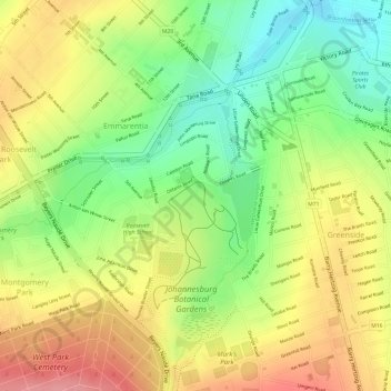
Name: Rose Gardens topographic map, elevation, terrain.
Average elevation: 1,613 m
Minimum elevation: 1,557 m
Maximum elevation: 1,664 m
Make a donation
Other topographic maps
Click on a map to view its topography, its elevation and its terrain.
Victoria Park
South Africa > Gauteng > City of Johannesburg Metropolitan Municipality > Johannesburg
Average elevation: 1,571 m
Melville Koppies East
South Africa > Gauteng > City of Johannesburg Metropolitan Municipality > Johannesburg
Average elevation: 1,669 m
Wemmer Pan
South Africa > Gauteng > City of Johannesburg Metropolitan Municipality > Johannesburg
Average elevation: 1,708 m
Eastleigh Spruit
South Africa > Gauteng > City of Johannesburg Metropolitan Municipality > Johannesburg
Average elevation: 1,586 m
Make a donation
Chartwell Gardens
South Africa > Gauteng > City of Johannesburg Metropolitan Municipality > Johannesburg
Average elevation: 1,703 m