
Queenstown-Lakes District topographic map
Interactive map
Click on the map to display elevation.
About this map
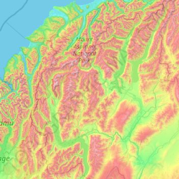
Name: Queenstown-Lakes District topographic map, elevation, terrain.
Location: Queenstown-Lakes District, Otago, New Zealand (-45.36757 168.11639 -43.95541 169.71978)
Average elevation: 832 m
Minimum elevation: -1 m
Maximum elevation: 2,819 m
Other topographic maps
Click on a map to view its topography, its elevation and its terrain.
Queenstown
New Zealand > Otago > Queenstown-Lakes District
Queenstown, Queenstown-Lakes District, Otago, 9348, New Zealand
Average elevation: 592 m
Makarora River
New Zealand > Otago > Queenstown-Lakes District
Makarora River, Queenstown-Lakes District, Otago, 9346, New Zealand
Average elevation: 1,081 m
Mount Pisa
New Zealand > Otago > Queenstown-Lakes District
Mount Pisa, Queenstown-Lakes District, Otago, New Zealand
Average elevation: 1,739 m
Alexandra
New Zealand > Otago > Central Otago District > Vincent Community
Alexandra, Vincent Community, Central Otago District, Otago, 9320, New Zealand
Average elevation: 241 m
Mount Pisa
New Zealand > Otago > Central Otago District > Cromwell Community
Mount Pisa, Cromwell Community, Central Otago District, Otago, 9383, New Zealand
Average elevation: 230 m