Geolocate

Xinjiang topographic map

Interactive map

Click on the map to display elevation.

Xinjiang

A semiarid or desert climate (Köppen BSk or BWk, respectively) prevails in Xinjiang. The entire region has great seasonal differences in temperature with cold winters. The Turpan Depression often records some of the hottest temperatures nationwide in summer, with air temperatures easily exceeding 40 °C (104 °F). Winter temperatures regularly fall below −20 °C (−4 °F) in the far north and highest mountain elevations.

Wikipedia (CC-BY-SA 3.0)

About this map

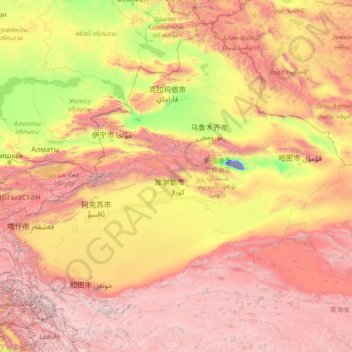
Name: Xinjiang topographic map, elevation, terrain.

Location: Xinjiang, China (34.33406 73.49973 49.17806 96.38764)

Average elevation: 2,188 m

Minimum elevation: -152 m

Maximum elevation: 7,404 m

Other topographic maps

Click on a map to view its topography, its elevation and its terrain.

Jade Dragon Snow Mountain

China > Yunnan > Lijiang City

The view of the massif from the gardens at the Black Dragon Pool (Heilong Tan) in Lijiang is noted as one of China's finest views. The mountain is part of Yulong Snow Mountain National Scenic Area and National Geological Park, an AAAAA-classified scenic area. The Park operates a tourist cable car that climbs…

Average elevation: 4,829 m

Laiwu

China > Guangdong Province > Longhua District

Average elevation: 113 m

Yaogouzi

China > Sichuan > Jiange County

Average elevation: 657 m

Shiwangmiao

China > Hubei > Zhuxi County

Average elevation: 915 m

Hejin

China > Shanxi > Hejin City > Chengqu Subdistrict

Average elevation: 529 m

Sishen

China > Gansu > Qingshui County

Average elevation: 1,568 m

dragon

China > Jiangsu > Nanjing City

Average elevation: 36 m

Shanghai

China

The golden age of Shanghai began with its elevation to municipality after it was separated from Jiangsu on 7 July 1927. This new Chinese municipality covered an area of 494.69 km2 (191.0 sq mi), including the modern-day districts of Baoshan, Yangpu, Zhabei, Nanshi, and Pudong, but excluded the foreign…

Average elevation: 5 m

Suping

China > Anhui > Lu'an

Average elevation: 474 m

Linyi

China > Shanxi > Linyi County > Linyi

Average elevation: 455 m

Houduan

China > Henan > Zhongmu County > Houduan

Average elevation: 111 m

Bishan

China > Chongqing > Bishan

Average elevation: 352 m

Tingri

China > Tibet > Tingri

Average elevation: 4,712 m

Hong Kong

China > Hong Kong > Hong Kong

Hong Kong has a humid subtropical climate (Köppen Cwa), characteristic of southern China. Summer is hot and humid, with occasional showers and thunderstorms and warm air from the southwest. Typhoons occur most often then, sometimes resulting in floods or landslides. Winters are mild and usually sunny at the…

Average elevation: 62 m

Wujiaochang

China > Shanghai > Wujiaochang

Average elevation: 6 m

Changdu

China > Tibet > Changdu

Average elevation: 4,027 m

Zhangzhou

China > Fujian > Zhangzhou

Average elevation: 103 m

Chaqa

China > Xinjiang > Chaqa

Average elevation: 2,083 m

Datong

China > Shanxi > Datong

Datong is a prefecture-level city in northern Shanxi Province in the People's Republic of China. It is located in the Datong Basin at an elevation of 1,040 metres (3,410 ft) and borders Inner Mongolia to the north and west and Hebei to the east. It had a population of 3,318,057 during the 2010 census, of whom…

Average elevation: 1,149 m

Liuzhou

China > Guangxi > Liuzhou

Average elevation: 124 m

Pingnan County

China > Guangxi > Chini

Average elevation: 36 m

Anshan

China > Liaoning > Anshan

Local transportation is primarily by bus or taxi. Anshan used to have a single tram line—along Zhonghua Avenue, through the city centre and past Angang main gate—but this has been closed and the tracks removed. Due to the flat topography of the city centre, bicycles are popular. Almost all roads have a…

Average elevation: 79 m

Longchi

China > Sichuan > Chengdu City > Longchi

Average elevation: 1,134 m

Pai Tau Tsuen

China > Hong Kong > Sha Tin > Pai Tau Tsuen

Average elevation: 104 m

Xipeng

China > Chongqing > Xipeng

Average elevation: 268 m

Ordos

China > Inner Mongolia > Ordos > Qingchunshan Subdistrict

Average elevation: 1,372 m

Puyang River

China > Sichuan > Dujiangyan City

Average elevation: 720 m