
Żary County topographic map
Interactive map
Click on the map to display elevation.
About this map
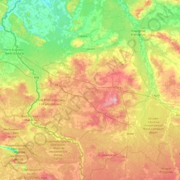
Name: Żary County topographic map, elevation, terrain.
Location: Żary County, Lubusz Voivodeship, Poland (51.36319 14.64994 51.89376 15.27357)
Average elevation: 120 m
Minimum elevation: 47 m
Maximum elevation: 227 m
Other topographic maps
Click on a map to view its topography, its elevation and its terrain.
Żary
Poland > Lubusz Voivodeship > Żary County
Żary, Żary County, Lubusz Voivodeship, Poland
Average elevation: 163 m
Krosno Odrzańskie County
Krosno Odrzańskie County, Lubusz Voivodeship, Poland
Average elevation: 67 m
Gorajec
Poland > Lubusz Voivodeship > Sulęcin County
Gorajec, gmina Sulęcin, Sulęcin County, Lubusz Voivodeship, Poland
Average elevation: 170 m
Zielona Góra
Poland > Lubusz Voivodeship > Zielona Góra
Zielona Góra, Lubusz Voivodeship, Poland
Average elevation: 90 m
Przytoczna
Poland > Lubusz Voivodeship > Przytoczna
Przytoczna, gmina Przytoczna, powiat międzyrzecki, Lubusz Voivodeship, 66-340, Poland
Average elevation: 65 m
Krosno Odrzańskie
Poland > Lubusz Voivodeship > Krosno Odrzańskie
Krosno Odrzańskie, gmina Krosno Odrzańskie, powiat krośnieński, Lubusz Voivodeship, Poland
Average elevation: 54 m
Międzyrzecz
Poland > Lubusz Voivodeship > Międzyrzecz
Międzyrzecz, gmina Międzyrzecz, powiat międzyrzecki, Lubusz Voivodeship, 66-300, Poland
Average elevation: 52 m