
Thank you for supporting this site ❤️
Make a donation
Make a donation
Kubusi River topographic map
Click on the map to display elevation.
Thank you for supporting this site ❤️
Make a donation
Make a donation
About this map
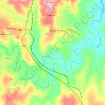
Name: Kubusi River topographic map, elevation, terrain.
Average elevation: 799 m
Minimum elevation: 715 m
Maximum elevation: 923 m
Thank you for supporting this site ❤️
Make a donation
Make a donation
Other topographic maps
Click on a map to view its topography, its elevation and its terrain.
Cathcart
South Africa > Eastern Cape > Amathole District Municipality > Amahlathi Local Municipality
Average elevation: 1,196 m
Keiskammahoek
South Africa > Eastern Cape > Amathole District Municipality > Amahlathi Local Municipality
Average elevation: 669 m
Cumakala
South Africa > Eastern Cape > Amathole District Municipality > Amahlathi Local Municipality > Cumakala
Average elevation: 836 m
Ntaba kaNdoda Peak
South Africa > Eastern Cape > Amathole District Municipality > Amahlathi Local Municipality
Average elevation: 747 m
Thank you for supporting this site ❤️
Make a donation
Make a donation