
Emnambithi/Ladysmith Local Municipality topographic map
Interactive map
Click on the map to display elevation.
About this map
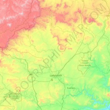
Name: Emnambithi/Ladysmith Local Municipality topographic map, elevation, terrain.
Average elevation: 1,244 m
Minimum elevation: 642 m
Maximum elevation: 2,299 m
Other topographic maps
Click on a map to view its topography, its elevation and its terrain.
Colenso
South Africa > KwaZulu-Natal > Uthukela District Municipality > Emnambithi/Ladysmith Local Municipality
Average elevation: 967 m
Tugela Falls
South Africa > KwaZulu-Natal > Uthukela District Municipality > Okhahlamba Local Municipality
First, many now believe that Angel Falls is not as tall as was claimed in the initial survey carried out by American journalist Ruth Robertson in 1949. The quoted figure of 979 m (3,212 ft) corresponds almost precisely with the difference in altitude between the top of the falls and the confluence of the Rio…
Average elevation: 2,773 m
Cathkin Peak
South Africa > KwaZulu-Natal > Uthukela District Municipality > Okhahlamba Local Municipality
Average elevation: 2,660 m
WINTERBURN
South Africa > KwaZulu-Natal > Uthukela District Municipality > Okhahlamba Local Municipality
Average elevation: 1,315 m
Estcourt
South Africa > KwaZulu-Natal > Uthukela District Municipality > Umtshezi Local Municipality
Average elevation: 1,204 m
Weenen
South Africa > KwaZulu-Natal > Uthukela District Municipality > Umtshezi Local Municipality
Average elevation: 870 m
Estcourt
South Africa > KwaZulu-Natal > Uthukela District Municipality > Umtshezi Local Municipality
Average elevation: 1,204 m
Royal Natal National Park
South Africa > KwaZulu-Natal > Uthukela District Municipality > Okhahlamba Local Municipality > Thendele
Average elevation: 1,869 m
Weenen
South Africa > KwaZulu-Natal > Uthukela District Municipality > Umtshezi Local Municipality
Average elevation: 870 m
Van Reenen
South Africa > KwaZulu-Natal > Uthukela District Municipality > Emnambithi/Ladysmith Local Municipality > Van Reenen
Average elevation: 1,662 m
Hambrook
South Africa > KwaZulu-Natal > Uthukela District Municipality > Okhahlamba Local Municipality
Average elevation: 1,128 m