
Ķekava topographic map
Interactive map
Click on the map to display elevation.
About this map
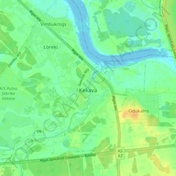
Name: Ķekava topographic map, elevation, terrain.
Location: Ķekava, Ķekavas pagasts, Ķekavas novads, Livland, Lettland (56.81074 24.18457 56.84219 24.25733)
Average elevation: 10 m
Minimum elevation: -2 m
Maximum elevation: 26 m
Other topographic maps
Click on a map to view its topography, its elevation and its terrain.
Odukalns
Lettland > Livland > Ķekavas pagasts
Odukalns, Ķekavas pagasts, Ķekavas novads, Livland, LV-2123, Lettland
Average elevation: 12 m