
Odukalns topographic map
Interactive map
Click on the map to display elevation.
About this map
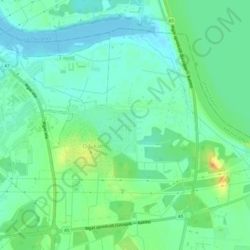
Name: Odukalns topographic map, elevation, terrain.
Average elevation: 12 m
Minimum elevation: -2 m
Maximum elevation: 35 m
Other topographic maps
Click on a map to view its topography, its elevation and its terrain.
Ķekava
Lettland > Livland > Ķekavas pagasts
Ķekava, Ķekavas pagasts, Ķekavas novads, Livland, Lettland
Average elevation: 10 m