
Jurong Hill topographic map
Interactive map
Click on the map to display elevation.
About this map
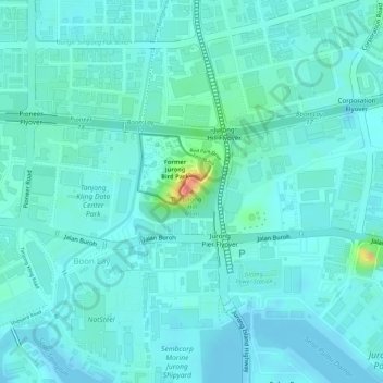
Name: Jurong Hill topographic map, elevation, terrain.
Location: Jurong Hill, Southwest, 628925, Singapore (1.31739 103.70781 1.31749 103.70791)
Average elevation: 11 m
Minimum elevation: -1 m
Maximum elevation: 60 m
Other topographic maps
Click on a map to view its topography, its elevation and its terrain.
Bajau Hill
Singapore > Southwest > Singapore
Bajau Hill, Singapore, Southwest, 636921, Singapore
Average elevation: 15 m
Tanjong Pasir Laba
Tanjong Pasir Laba, Western Water Catchment, Southwest, 639937, Singapore
Average elevation: 4 m
Kent Ridge Park
Singapore > Southwest > Queenstown
Kent Ridge Park, Alexandra, Queenstown, Southwest, Singapore
Average elevation: 21 m