
Useldange topographic map
Interactive map
Click on the map to display elevation.
About this map
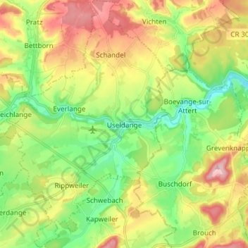
Name: Useldange topographic map, elevation, terrain.
Location: Useldange, Canton Redange, Luxembourg (49.73051 5.92049 49.80936 6.00536)
Average elevation: 296 m
Minimum elevation: 225 m
Maximum elevation: 395 m
Other topographic maps
Click on a map to view its topography, its elevation and its terrain.
Grosbous
Luxembourg > Canton Redange > Grosbous-Wahl
Grosbous, Grosbous-Wahl, Canton Redange, 9154, Luxembourg
Average elevation: 369 m
Noerdange
Noerdange, Beckerich, Canton Redange, 8550, Luxembourg
Average elevation: 284 m