
Make a donation
Bucks County topographic map
Click on the map to display elevation.
Make a donation
Bucks County
During the winter months, episodes of extreme cold and wind can occur with wind chill values < −16 °F (−27 °C). The plant hardiness zone at Haycock Mountain, elevation 968 ft (295 m), is 6b with an average annual extreme minimum air temperature of −4.6 °F (−20 °C). The average seasonal (Nov-Apr) snowfall total is between 26 and 36 inches (66 and 91 centimetres) depending on elevation and distance from the Atlantic Ocean. The average snowiest month is February which correlates with the annual peak in nor'easter activity. Some areas of the Piedmont farther south and along the river below New Hope are in hardiness zone 7a, as is the Atlantic Coastal Plain region of Bucks.
Make a donation
About this map
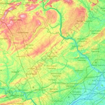
Name: Bucks County topographic map, elevation, terrain.
Location: Bucks County, Pennsylvania, United States (40.04980 -75.48393 40.60872 -74.72111)
Average elevation: 98 m
Minimum elevation: -2 m
Maximum elevation: 312 m
Make a donation
Other topographic maps
Click on a map to view its topography, its elevation and its terrain.
East Texas
United States > Pennsylvania > Lehigh County > Lower Macungie Township
Average elevation: 126 m
Valley Forge
United States > Pennsylvania > Chester County > Schuylkill Township
Average elevation: 78 m
Albrightsville
United States > Pennsylvania > Carbon County > Kidder Township
Average elevation: 498 m
Make a donation
Lake Keystone
United States > Pennsylvania > Armstrong County > Plumcreek Township
Keystone Lake (also known as Keystone Reservoir and Plum Creek Reservoir) is a reservoir in Armstrong County in the U.S. state of Pennsylvania. The elevation of Keystone Lake is 1,076 feet (328 m) above sea level.
Average elevation: 357 m
Brackney
United States > Pennsylvania > Susquehanna County > Silver Lake Township
Average elevation: 491 m
Dingmans Ferry
United States > Pennsylvania > Pike County > Delaware Township
Average elevation: 192 m
Make a donation
Middlebury Center
United States > Pennsylvania > Tioga County > Middlebury Township
Average elevation: 462 m
Woxall
United States > Pennsylvania > Montgomery County > Upper Salford Township
Average elevation: 98 m
Donegal Lake
United States > Pennsylvania > Westmoreland County > Donegal Township
Average elevation: 493 m
Make a donation
Centreville
United States > Pennsylvania > Lehigh County > Lower Macungie Township
Average elevation: 144 m
Bass Lake
United States > Pennsylvania > York County > Newberry Township > Valley Green
Average elevation: 143 m
Croydon Heights
United States > Pennsylvania > Bucks County > Bristol Township > Croydon
Average elevation: 10 m
Make a donation
Fitzwatertown
United States > Pennsylvania > Montgomery County > Upper Dublin Township
Average elevation: 86 m
Starview
United States > Pennsylvania > York County > East Manchester Township
Average elevation: 155 m
North Towanda
United States > Pennsylvania > Bradford County > North Towanda Township
Average elevation: 286 m
Make a donation
Make a donation
Make a donation
Freemont
United States > Pennsylvania > Chester County > West Nottingham Township
Average elevation: 115 m
Sturgeon
United States > Pennsylvania > Allegheny County > North Fayette Township
Average elevation: 334 m
Glade Mills
United States > Pennsylvania > Butler County > Middlesex Township
Average elevation: 359 m
Make a donation
Knickerbocker
United States > Pennsylvania > Chester County > Willistown Township
Average elevation: 127 m
Carlisle Springs
United States > Pennsylvania > Cumberland County > Middlesex Township
Average elevation: 182 m
Vance
United States > Pennsylvania > Washington County > South Strabane Township
Average elevation: 371 m
Sagamore Estates
United States > Pennsylvania > Pike County > Shohola Township
Average elevation: 412 m
Make a donation
Evansburg State Park
United States > Pennsylvania > Montgomery County > Worcester Township > Cedars
Average elevation: 70 m
Cross Fork
United States > Pennsylvania > Potter County > Stewardson Township
Average elevation: 467 m
Make a donation
Ithan
United States > Pennsylvania > Delaware County > Radnor Township > Saint Davids
Average elevation: 116 m
Drumore Center
United States > Pennsylvania > Lancaster County > Drumore Township
Average elevation: 175 m
Orefield
United States > Pennsylvania > Lehigh County > North Whitehall Township
Average elevation: 141 m
Make a donation
Mount Nebo Park
United States > Pennsylvania > Monroe County > East Stroudsburg > Twin Falls
Average elevation: 185 m
Blue Mountain
United States > Pennsylvania > Monroe County > Eldred Township
The ridge of Blue Mountain runs for 150 miles (240 km) through Pennsylvania, reaching an elevation of 2,270 feet (690 m) above sea level just north of the Pennsylvania Turnpike, near the borough of Newburg. Most of the ridgecrest, however, only reaches between 1,400 and 1,700 feet (430 and 520 m) in elevation.…
Average elevation: 242 m
Make a donation
Longwood Gardens
United States > Pennsylvania > Chester County > East Marlborough Township
Average elevation: 125 m
Nottingham County Park
United States > Pennsylvania > Chester County > West Nottingham Township
Average elevation: 137 m
Marble Hall
United States > Pennsylvania > Montgomery County > Whitemarsh Township
Average elevation: 64 m
Make a donation
Circleville
United States > Pennsylvania > Westmoreland County > North Huntingdon Township
Average elevation: 333 m
Make a donation
Chadds Ford Township
United States > Pennsylvania > Delaware County > Chadds Ford Township
Average elevation: 101 m
Strawberry Mansion
United States > Pennsylvania > Philadelphia County > Philadelphia
Average elevation: 31 m
Reinholds
United States > Pennsylvania > Lancaster County > West Cocalico Township
Average elevation: 159 m
Make a donation
Langhorne Gardens
United States > Pennsylvania > Bucks County > Middletown Township
Average elevation: 45 m
Make a donation
Hanover Junction
United States > Pennsylvania > York County > North Codorus Township
Average elevation: 187 m
Champion
United States > Pennsylvania > Allegheny County > North Fayette Township
Average elevation: 360 m
Make a donation
North Coplay
United States > Pennsylvania > Lehigh County > Whitehall > Cementon
Average elevation: 116 m
Fagleysville
United States > Pennsylvania > Montgomery County > New Hanover Township
Average elevation: 105 m
Kreidersville
United States > Pennsylvania > Northampton County > Allen Township
Average elevation: 151 m
Make a donation
Stiefler Corner
United States > Pennsylvania > Bedford County > Kimmel Township
Average elevation: 520 m
Make a donation
Leather Corner Post
United States > Pennsylvania > Lehigh County > Lowhill Township
Average elevation: 178 m
Welsh Mountain Nature Preserve
United States > Pennsylvania > Lancaster County > East Earl Township
Average elevation: 294 m
East Springfield
United States > Pennsylvania > Erie County > Springfield Township
Average elevation: 229 m
Make a donation
Raven Rock Mountain
United States > Pennsylvania > Adams County > Liberty Township
Average elevation: 312 m
Strickhousers
United States > Pennsylvania > York County > North Codorus Township
Average elevation: 205 m
Make a donation
Pocono Lake
United States > Pennsylvania > Monroe County > Tobyhanna Township
Average elevation: 543 m
Intercourse
United States > Pennsylvania > Lancaster County > Leacock Township
Average elevation: 127 m
Make a donation
East Waterford
United States > Pennsylvania > Juniata County > Tuscarora Township
Average elevation: 257 m
Make a donation
Make a donation
Faylor Lake
United States > Pennsylvania > Snyder County > Spring Township > Beaver Springs
Average elevation: 197 m
Gladwyne
United States > Pennsylvania > Montgomery County > Lower Merion Township
Average elevation: 92 m
11th and Pike Playground
United States > Pennsylvania > Berks County > Reading
Average elevation: 132 m
Make a donation