
Riga topographic map
Interactive map
Click on the map to display elevation.
About this map
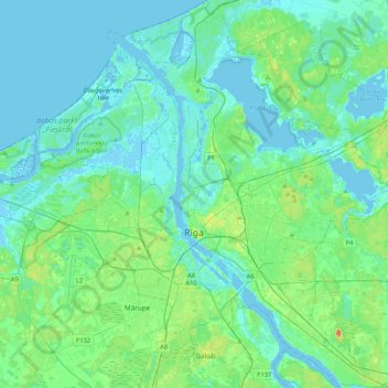
Name: Riga topographic map, elevation, terrain.
Location: Riga, Vidzeme, Latvia (56.85735 23.93255 57.08611 24.32450)
Average elevation: 7 m
Minimum elevation: -5 m
Maximum elevation: 39 m
Other topographic maps
Click on a map to view its topography, its elevation and its terrain.
Gauja National Park
Gauja National Park, Slikts ceļš, Edernieki, Pārgaujas novads, Vidzeme, LV-4146, Latvia
Average elevation: 93 m