
Cordillera topographic map
Interactive map
Click on the map to display elevation.
About this map
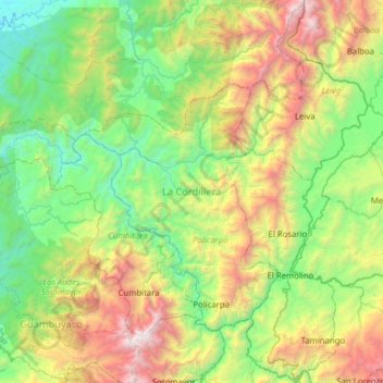
Name: Cordillera topographic map, elevation, terrain.
Location: Cordillera, Nariño, Colombia (1.50060 -77.71813 2.12503 -77.20363)
Average elevation: 1,087 m
Minimum elevation: 33 m
Maximum elevation: 3,600 m
Mountain ranges of this type have a complex structure, usually the result of folding and faulting accompanied by volcanic activity. In South America the ranges include numerous volcanic peaks. The Andes cordillera has Ojos del Salado, the highest active volcano in the world and second highest point in the Western Hemisphere. (Though not itself a volcano, Argentina's Mt. Aconcagua, at 6,960 metres (22,834 feet) high, is the highest point in the Western Hemisphere.) A number of the volcanoes have been active in historical times. Aside from the volcanic peaks, the crests include many narrow ridges, some of which reach into the zone of permanent snow. Between the ranges there are numerous inhabited valleys, basins, and low plateaux with a wide range of elevations.
Other topographic maps
Click on a map to view its topography, its elevation and its terrain.