
Make a donation
Thaba Chweu Ward 13 topographic map
Click on the map to display elevation.
Make a donation
About this map
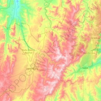
Name: Thaba Chweu Ward 13 topographic map, elevation, terrain.
Average elevation: 1,458 m
Minimum elevation: 778 m
Maximum elevation: 2,276 m
Make a donation
Other topographic maps
Click on a map to view its topography, its elevation and its terrain.
Lowveld View
South Africa > Mpumalanga > Ehlanzeni District Municipality > Thaba Chweu Local Municipality > Frankfurt
Average elevation: 1,104 m
Pilgrim's Rest
South Africa > Mpumalanga > Ehlanzeni District Municipality > Thaba Chweu Local Municipality
Average elevation: 1,352 m
Mashishing
South Africa > Mpumalanga > Ehlanzeni District Municipality > Thaba Chweu Local Municipality
Average elevation: 1,421 m
Khutsong
South Africa > Mpumalanga > Ehlanzeni District Municipality > Thaba Chweu Local Municipality
Average elevation: 1,288 m
Make a donation
Mount Anderson
South Africa > Mpumalanga > Ehlanzeni District Municipality > Thaba Chweu Local Municipality > Mount Anderson
Average elevation: 1,173 m