
Thank you for supporting this site ❤️
Make a donation
Make a donation
Pilgrim's Rest topographic map
Click on the map to display elevation.
Thank you for supporting this site ❤️
Make a donation
Make a donation
About this map
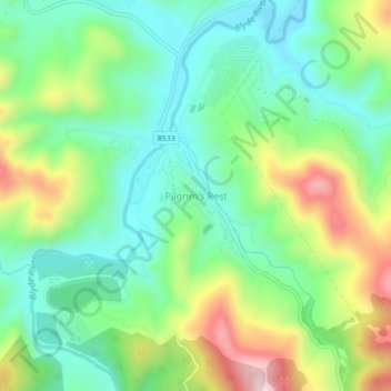
Name: Pilgrim's Rest topographic map, elevation, terrain.
Average elevation: 1,352 m
Minimum elevation: 1,215 m
Maximum elevation: 1,621 m
Thank you for supporting this site ❤️
Make a donation
Make a donation
Other topographic maps
Click on a map to view its topography, its elevation and its terrain.
Mashishing
South Africa > Mpumalanga > Ehlanzeni District Municipality > Thaba Chweu Local Municipality
Average elevation: 1,421 m
Thaba Chweu Ward 13
South Africa > Mpumalanga > Ehlanzeni District Municipality > Thaba Chweu Local Municipality
Average elevation: 1,458 m
Blyderivierpoort Dam
South Africa > Mpumalanga > Ehlanzeni District Municipality > Thaba Chweu Local Municipality
Average elevation: 835 m