
Make a donation
Southern Province topographic map
Click on the map to display elevation.
Make a donation
Southern Province
Southern Province is bordered along Zimbabwe in the south divided by Victoria Falls, Central in the north, Western Province in the west and Lusaka Province in the northeast. The general topography of the province is characterized by uplifted planation surfaces. The general elevation of the nation as a whole is tended towards West to East from the Kalahari Basin. The level of land falls from the upper Congo towards the Zambezi depression in the South forming a plateau.
Make a donation
About this map
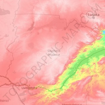
Name: Southern Province topographic map, elevation, terrain.
Location: Southern Province, Zambia (-18.07621 24.97167 -15.26662 28.92595)
Average elevation: 1,007 m
Minimum elevation: 420 m
Maximum elevation: 1,492 m
Make a donation
Other topographic maps
Click on a map to view its topography, its elevation and its terrain.
Lusaka
Lusaka (/luːˈsɑːkə/; loo-SAH-kə) is the capital and largest city of Zambia. It is one of the fastest-developing cities in southern Africa. Lusaka is in the southern part of the central plateau at an elevation of about 1,279 metres (4,196 ft). As of 2019, the city's population was about 3.3 million, while…
Average elevation: 1,227 m
Chinsali
The geographical coordinates of Chinsali Town are 10°33'08.0"S, 32°04'09.0"E (Latitude:-10.552222; Longitude:32.069167). The town is nestled at an average elevation of 1,383 metres (4,537 ft) above mean sea level.
Average elevation: 1,294 m
Make a donation
Katete
Katete is a medium-sized town in the Eastern Province of Zambia, and is headquarters of Katete District. The town is at the foot of rocky hills which lie to its east, including Mpangwe Hill and Kangarema Hill, which rise to 1600 m. The hills are surrounded by cultivated fields. Katete lies on the Great East…
Average elevation: 1,069 m
Make a donation
Mporokoso
Mporokoso (also spelled and pronounced 'Mpolokoso' and 'Mumpolokoso') is a town in the Northern Province of Zambia, lying at an elevation of nearly 1500 m on the flat plateau about 75 km south east of Lake Mweru Wantipa and 100 km south-west of Lake Tanganyika. It is named for Chief Mporokoso (also spelled…
Average elevation: 1,439 m
Make a donation
Solwezi
Zambia > North-Western Province
Solwezi is located on the Chingola–Solwezi–Mwinilunga Road (T5 Road of Zambia), approximately 177 kilometres (110 mi) north-west of Chingola and approximately 275 kilometres (171 mi) south-east of Mwinilunga, in the extreme northwest of the country. The geographical coordinates of the city…
Average elevation: 1,352 m
Make a donation
Solwezi
Zambia > North-Western Province
Solwezi is located on the Chingola–Solwezi–Mwinilunga Road (T5 Road of Zambia), approximately 177 kilometres (110 mi) north-west of Chingola and approximately 275 kilometres (171 mi) south-east of Mwinilunga, in the extreme northwest of the country. The geographical coordinates of the city…
Average elevation: 1,352 m
Lusaka
Lusaka (/luːˈsɑːkə/ loo-SAH-kə) is the capital and largest city of Zambia. It is one of the fastest-developing cities in southern Africa. Lusaka is in the southern part of the central plateau at an elevation of about 1,279 metres (4,196 ft). As of 2019, the city's population was about 3.3 million, while…
Average elevation: 1,227 m
Make a donation
Mbala
The town is at the edge of the plateau covering most of Zambia, at an elevation of 1670 m, about 900 m higher than Lake Tanganyika, which comes within 22 km (straight-line distance). The escarpment above the lake is the end of the Albertine Rift, the western branch of the East Africa Rift, and the Mbala area…
Average elevation: 1,632 m
Make a donation
Mporokoso
Mporokoso (also spelled and pronounced 'Mpolokoso' and 'Mumpolokoso') is a town in the Northern Province of Zambia, lying at an elevation of nearly 1500 m on the flat plateau about 75 km south east of Lake Mweru Wantipa and 100 km south-west of Lake Tanganyika. It is named for Chief Mporokoso (also spelled…
Average elevation: 1,439 m
Chinsali
The geographical coordinates of Chinsali Town are 10°33'08.0"S, 32°04'09.0"E (Latitude:-10.552222; Longitude:32.069167). The town is nestled at an average elevation of 1,383 metres (4,537 ft) above mean sea level.
Average elevation: 1,294 m
Make a donation
Lusaka
Lusaka (/luːˈsɑːkə/ loo-SAH-kə) is the capital and largest city of Zambia. It is one of the fastest-developing cities in southern Africa. Lusaka is in the southern part of the central plateau at an elevation of about 1,279 metres (4,196 ft). As of 2019, the city's population was about 3.3 million, while…
Average elevation: 1,227 m
Make a donation
Make a donation
Make a donation
Nakonde
This is approximately 350 kilometres (217 mi), by road, north of Mpika, the largest city in the province. The geographical coordinates of the town are: 09°19'38.0"S, 32°45'30.0"E (Latitude:-9.327222; Longitude:32.758333). The average elevation of Nakonde is about 1,306 metres (4,285 ft), above sea level.…
Average elevation: 1,613 m
Solwezi
Zambia > North-Western Province
Solwezi is located on the Chingola–Solwezi–Mwinilunga Road (T5 Road of Zambia), approximately 177 kilometres (110 mi) north-west of Chingola and approximately 275 kilometres (171 mi) south-east of Mwinilunga, in the extreme northwest of the country. The geographical coordinates of the city…
Average elevation: 1,352 m
Make a donation
Lusaka
Lusaka (/luːˈsɑːkə/ loo-SAH-kə) is the capital and largest city of Zambia. It is one of the fastest-developing cities in southern Africa. Lusaka is in the southern part of the central plateau at an elevation of about 1,279 metres (4,196 ft). As of 2019, the city's population was about 3.3 million, while…
Average elevation: 1,227 m
Make a donation
Make a donation
Make a donation
Make a donation
Make a donation
Lusaka
Lusaka (/luːˈsɑːkə/; loo-SAH-kə) is the capital and largest city of Zambia. It is one of the fastest-developing cities in southern Africa. Lusaka is in the southern part of the central plateau at an elevation of about 1,279 metres (4,196 ft). As of 2019, the city's population was about 3.3 million, while…
Average elevation: 1,227 m
Make a donation
Mwinilunga
Zambia > North-Western Province
Mwinilunga sits in the extreme north-western corner of the country, close to the international borders with Angola and the Democratic Republic of the Congo. The geographical coordinates of Mwinilunga, Zambia are:11°43'02.0"S, 24°25'44.0"E (Latitude:-11.717222; Longitude:24.428889). The average elevation of…
Average elevation: 1,345 m
Make a donation
Make a donation
Chipata
Chipata is located on the Great East Road, approximately 570 kilometres (354 mi) east of Lusaka, the capital city of Zambia. This is about 150 kilometres (93 mi) west of Lilongwe, the capital city of Malawi. The geographical coordinates of Chipata are 13°38′43.0″S, 32°38′47.0″E. The average elevation…
Average elevation: 1,133 m
Make a donation
Mbala
The town is at the edge of the plateau covering most of Zambia, at an elevation of 1670 m, about 900 m higher than Lake Tanganyika, which comes within 22 km (straight-line distance). The escarpment above the lake is the end of the Albertine Rift, the western branch of the East Africa Rift, and the Mbala area…
Average elevation: 1,632 m