
Nederweert topographic map
Interactive map
Click on the map to display elevation.
About this map
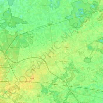
Name: Nederweert topographic map, elevation, terrain.
Location: Nederweert, Limbourg, Pays-Bas (51.23692 5.64400 51.34688 5.87782)
Average elevation: 31 m
Minimum elevation: 22 m
Maximum elevation: 40 m
Other topographic maps
Click on a map to view its topography, its elevation and its terrain.
Herkenbosch
Pays-Bas > Limbourg > Herkenbosch > Herkenbosch
Herkenbosch, Roerdalen, Limbourg, Pays-Bas, 6075, Pays-Bas
Average elevation: 31 m
Bassin
Pays-Bas > Limbourg > Maastricht
Bassin, Maasboulevard, Boschstraatkwartier, Maastricht, Limbourg, Pays-Bas, 6211, Pays-Bas
Average elevation: 55 m
Born
Pays-Bas > Limbourg > Sittard-Geleen
Born, Sittard-Geleen, Limbourg, Pays-Bas
Average elevation: 34 m