
Make a donation
Nelson Mandela Bay Metropolitan Municipality topographic map
Click on the map to display elevation.
Make a donation
About this map
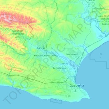
Name: Nelson Mandela Bay Metropolitan Municipality topographic map, elevation, terrain.
Average elevation: 158 m
Minimum elevation: -1 m
Maximum elevation: 1,143 m
Make a donation
Other topographic maps
Click on a map to view its topography, its elevation and its terrain.
Gqeberha
South Africa > Eastern Cape > Nelson Mandela Bay Metropolitan Municipality
Average elevation: 37 m
Junction 6
South Africa > Eastern Cape > Sarah Baartman District Municipality > Camdeboo Local Municipality
Average elevation: 799 m
Graaff-Reinet
South Africa > Eastern Cape > Sarah Baartman District Municipality > Camdeboo Local Municipality
Average elevation: 873 m
Pearston
South Africa > Eastern Cape > Sarah Baartman District Municipality > Blue Crane Route Local Municipality
Pearston is located about 160 kilometres (100 mi) north of Port Elizabeth, on the banks of the Voël River. It is situated at an altitude of 710 metres (2,330 ft) on the Camdeboo plain. The Coetzeesberge, a spur of the Sneeuberge (a mountain), lie to the north, and the Groot-Bruintjieshoogte lie to the east.…
Average elevation: 728 m
Stutterheim
South Africa > Eastern Cape > Amathole District Municipality > Amahlathi Local Municipality
Average elevation: 834 m
Make a donation
Cookhouse
South Africa > Eastern Cape > Sarah Baartman District Municipality > Blue Crane Route Local Municipality
Average elevation: 669 m
Qamata River
South Africa > Eastern Cape > Chris Hani District Municipality > Intsika Yethu Local Municipality
Average elevation: 894 m
Tina River
South Africa > Eastern Cape > O.R. Tambo District Municipality > Mhlontlo Local Municipality
Average elevation: 557 m
St. Francis Bay
South Africa > Eastern Cape > Sarah Baartman District Municipality > Kouga Local Municipality
Average elevation: 25 m
Tarkastad
South Africa > Eastern Cape > Chris Hani District Municipality > Tsolwana Local Municipality
Scientists have stated that Tarkastad has one of the healthiest climates in the world. Winters are cold with frequent snowfalls on high lying mountain tops, while summers are hot and dry. Tarkastad which is situated at an elevation of 1,304 metres normally receives about 335mm of rain per year, with most…
Average elevation: 1,347 m
Make a donation
Komani
South Africa > Eastern Cape > Chris Hani District Municipality > Lukhanji Local Municipality
Average elevation: 1,147 m
East London
South Africa > Eastern Cape > Buffalo City Metropolitan Municipality
Average elevation: 72 m
Ekuphumleni
South Africa > Eastern Cape > Buffalo City Metropolitan Municipality
Average elevation: 383 m
Ngcobo
South Africa > Eastern Cape > Chris Hani District Municipality > Engcobo Local Municipality
Average elevation: 959 m
Naledi
South Africa > Eastern Cape > Joe Gqabi District Municipality > Senqu Local Municipality
Average elevation: 1,518 m
Make a donation
Dordrecht
South Africa > Eastern Cape > Chris Hani District Municipality > Emalahleni Local Municipality
Average elevation: 1,678 m
Cala
South Africa > Eastern Cape > Chris Hani District Municipality > Sakhisizwe Local Municipality
Average elevation: 1,297 m
Barkly East
South Africa > Eastern Cape > Joe Gqabi District Municipality > Senqu Local Municipality
Barkly East (Afrikaans: Barkly-Oos) is a town in Eastern Cape Province, South Africa, seat of the Joe Gqabi District Municipality, and 117 km by road E.S.E. of Aliwal North, lying in the mountainous area just south of Lesotho. The town lies at the southern tip of the Drakensberg on the Langkloofspruit, a…
Average elevation: 1,838 m
East London
South Africa > Eastern Cape > Buffalo City Metropolitan Municipality
Average elevation: 72 m
Make a donation
Tsolo
South Africa > Eastern Cape > O.R. Tambo District Municipality > Mhlontlo Local Municipality
Average elevation: 973 m
Bele
South Africa > Eastern Cape > O.R. Tambo District Municipality > Mhlontlo Local Municipality
Average elevation: 1,132 m
Barkly East
South Africa > Eastern Cape > Joe Gqabi District Municipality > Senqu Local Municipality
Barkly East (Afrikaans: Barkly-Oos) is a town in Eastern Cape Province, South Africa, seat of the Joe Gqabi District Municipality, and 117 km by road E.S.E. of Aliwal North, lying in the mountainous area just south of Lesotho. The town lies at the southern tip of the Drakensberg on the Langkloofspruit, a…
Average elevation: 1,838 m
East London
South Africa > Eastern Cape > Buffalo City Metropolitan Municipality
Average elevation: 72 m
Qumbu
South Africa > Eastern Cape > O.R. Tambo District Municipality > Mhlontlo Local Municipality
Average elevation: 987 m
Make a donation
Bedford
South Africa > Eastern Cape > Amathole District Municipality > Nxuba Local Municipality
Average elevation: 850 m
Kendrew
South Africa > Eastern Cape > Sarah Baartman District Municipality > Camdeboo Local Municipality
Average elevation: 614 m
Nqanqarhu
South Africa > Eastern Cape > Joe Gqabi District Municipality > Elundini Local Municipality
Average elevation: 1,349 m
Tarkastad
South Africa > Eastern Cape > Chris Hani District Municipality > Tsolwana Local Municipality
Scientists have stated that Tarkastad has one of the healthiest climates in the world. Winters are cold with frequent snowfalls on high lying mountain tops, while summers are hot and dry. Tarkastad which is situated at an elevation of 1,304 metres normally receives about 335mm of rain per year, with most…
Average elevation: 1,347 m
Cedarville
South Africa > Eastern Cape > Alfred Nzo District Municipality > Matatiele Local Municipality
Average elevation: 1,495 m
Make a donation
Tarkastad
South Africa > Eastern Cape > Chris Hani District Municipality > Tsolwana Local Municipality
Scientists have stated that Tarkastad has one of the healthiest climates in the world. Winters are cold with frequent snowfalls on high lying mountain tops, while summers are hot and dry. Tarkastad which is situated at an elevation of 1,304 metres normally receives about 335mm of rain per year, with most…
Average elevation: 1,347 m
St. Francis Bay
South Africa > Eastern Cape > Sarah Baartman District Municipality > Kouga Local Municipality
Average elevation: 25 m
Gqeberha
South Africa > Eastern Cape > Nelson Mandela Bay Metropolitan Municipality
Average elevation: 37 m
Middelburg
South Africa > Eastern Cape > Chris Hani District Municipality > Inxuba Yethemba Local Municipality
Average elevation: 1,254 m
Make a donation
Cannon Rocks
South Africa > Eastern Cape > Sarah Baartman District Municipality > Ndlambe Local Municipality
Average elevation: 35 m
Former Bayworld Dolphinarium
South Africa > Eastern Cape > Nelson Mandela Bay Metropolitan Municipality > Gqeberha / Port Elizabeth
Average elevation: 18 m
Adelaide
South Africa > Eastern Cape > Amathole District Municipality > Nxuba Local Municipality
Average elevation: 619 m
Cape Recife
South Africa > Eastern Cape > Nelson Mandela Bay Metropolitan Municipality > Gqeberha > Noordhoek
Average elevation: 3 m
Patensie
South Africa > Eastern Cape > Sarah Baartman District Municipality > Kouga Local Municipality
Average elevation: 97 m
Make a donation
Breidbach
South Africa > Eastern Cape > Buffalo City Metropolitan Municipality
Average elevation: 424 m
Komani
South Africa > Eastern Cape > Chris Hani District Municipality > Lukhanji Local Municipality
Average elevation: 1,147 m
Aliwal North
South Africa > Eastern Cape > Joe Gqabi District Municipality > Maletswai Local Municipality
Average elevation: 1,336 m
Aberdeen
South Africa > Eastern Cape > Sarah Baartman District Municipality > Camdeboo Local Municipality
Average elevation: 757 m
Make a donation
Ludeke Dam
South Africa > Eastern Cape > Alfred Nzo District Municipality > Mbizana Local Municipality
Average elevation: 810 m
Hole in the Wall
South Africa > Eastern Cape > O.R. Tambo District Municipality > King Sabata Dalindyebo Local Municipality
Average elevation: 44 m
Motherwell
South Africa > Eastern Cape > Nelson Mandela Bay Metropolitan Municipality
Average elevation: 67 m
Mount Shepstone
South Africa > Eastern Cape > Chris Hani District Municipality > Lukhanji Local Municipality
Average elevation: 1,701 m
Make a donation
Mount Pleasant
South Africa > Eastern Cape > O.R. Tambo District Municipality > King Sabata Dalindyebo Local Municipality
Average elevation: 708 m
Zwelitsha
South Africa > Eastern Cape > Buffalo City Metropolitan Municipality
Average elevation: 397 m
Ngcobo
South Africa > Eastern Cape > Chris Hani District Municipality > Engcobo Local Municipality
Average elevation: 950 m
Komani
South Africa > Eastern Cape > Chris Hani District Municipality > Lukhanji Local Municipality
Average elevation: 1,147 m
Mzimvubu
South Africa > Eastern Cape > Alfred Nzo District Municipality > Umzimvubu Local Municipality
Average elevation: 1,041 m
Make a donation
Lusikisiki
South Africa > Eastern Cape > O.R. Tambo District Municipality > Ingquza Hill Local Municipality
Average elevation: 563 m
Kouga Dam
South Africa > Eastern Cape > Sarah Baartman District Municipality > Kouga Local Municipality
Average elevation: 275 m
Nohlazana
South Africa > Eastern Cape > Buffalo City Metropolitan Municipality
Average elevation: 247 m
Cofimvaba
South Africa > Eastern Cape > Chris Hani District Municipality > Intsika Yethu Local Municipality
Average elevation: 997 m
eMaXesibeni (Mount Ayliff)
South Africa > Eastern Cape > Alfred Nzo District Municipality > Umzimvubu Local Municipality
Average elevation: 1,128 m
Make a donation
Tlokoeng
South Africa > Eastern Cape > Joe Gqabi District Municipality > Elundini Local Municipality
Average elevation: 1,480 m
Sterkspruit
South Africa > Eastern Cape > Joe Gqabi District Municipality > Senqu Local Municipality
Average elevation: 1,486 m
Tabankulu
South Africa > Eastern Cape > Alfred Nzo District Municipality > Ntabankulu Local Municipality
Average elevation: 1,111 m
Mandlovini
South Africa > Eastern Cape > O.R. Tambo District Municipality > King Sabata Dalindyebo Local Municipality > Lalini
Average elevation: 858 m
Ntabelanga
South Africa > Eastern Cape > Joe Gqabi District Municipality > Elundini Local Municipality
Average elevation: 1,514 m
Make a donation
Nahoon Dam
South Africa > Eastern Cape > Buffalo City Metropolitan Municipality
Average elevation: 177 m
KwaBhaca (Mount Frere)
South Africa > Eastern Cape > Alfred Nzo District Municipality > Umzimvubu Local Municipality
Average elevation: 1,116 m
eMaXesibeni (Mount Ayliff)
South Africa > Eastern Cape > Alfred Nzo District Municipality > Umzimvubu Local Municipality
Average elevation: 1,128 m
Bizana
South Africa > Eastern Cape > Alfred Nzo District Municipality > Mbizana Local Municipality
Average elevation: 823 m
Make a donation
Zizamele
South Africa > Eastern Cape > Amathole District Municipality > Mnquma Local Municipality
Average elevation: 613 m
Macubeni Dam
South Africa > Eastern Cape > Chris Hani District Municipality > Emalahleni Local Municipality
Average elevation: 1,347 m
Baakens River
South Africa > Eastern Cape > Nelson Mandela Bay Metropolitan Municipality > Gqeberha
Average elevation: 27 m
Tina Falls
South Africa > Eastern Cape > O.R. Tambo District Municipality > Mhlontlo Local Municipality
Average elevation: 565 m
Glen Melville Dam
South Africa > Eastern Cape > Sarah Baartman District Municipality > Makana Local Municipality
Average elevation: 286 m
Make a donation
East London
South Africa > Eastern Cape > Buffalo City Metropolitan Municipality
Average elevation: 72 m
Qwidlana
South Africa > Eastern Cape > Alfred Nzo District Municipality > Umzimvubu Local Municipality
Average elevation: 1,190 m
Mount Baziya
South Africa > Eastern Cape > O.R. Tambo District Municipality > King Sabata Dalindyebo Local Municipality
Average elevation: 1,345 m
Grey Dam
South Africa > Eastern Cape > Sarah Baartman District Municipality > Makhanda
Average elevation: 600 m
Make a donation
eMazizini
South Africa > Eastern Cape > Amathole District Municipality > Mnquma Local Municipality
Average elevation: 585 m
Cofimvaba
South Africa > Eastern Cape > Chris Hani District Municipality > Intsika Yethu Local Municipality
Average elevation: 997 m
Dutywa
South Africa > Eastern Cape > Amathole District Municipality > Mbhashe Local Municipality
Average elevation: 833 m
Jeffreys Bay
South Africa > Eastern Cape > Sarah Baartman District Municipality > Kouga Local Municipality
Average elevation: 30 m
Komani
South Africa > Eastern Cape > Chris Hani District Municipality > Lukhanji Local Municipality > Komani
Average elevation: 1,064 m
Make a donation
Nohlazana
South Africa > Eastern Cape > Buffalo City Metropolitan Municipality
Average elevation: 247 m
Ngqamakhwe
South Africa > Eastern Cape > Amathole District Municipality > Mnquma Local Municipality
Average elevation: 998 m
Gxulu
South Africa > Eastern Cape > Amathole District Municipality > Amahlathi Local Municipality > Keiskammahoek
Average elevation: 809 m
eMaXesibeni (Mount Ayliff)
South Africa > Eastern Cape > Alfred Nzo District Municipality > Umzimvubu Local Municipality
Average elevation: 1,128 m
Ludeke Dam
South Africa > Eastern Cape > Alfred Nzo District Municipality > Mbizana Local Municipality
Average elevation: 810 m
Make a donation
Redcliff Waterfall
South Africa > Eastern Cape > Amathole District Municipality > Nkonkobe Local Municipality
Average elevation: 1,062 m
Kubusi
South Africa > Eastern Cape > Amathole District Municipality > Amahlathi Local Municipality
Average elevation: 1,397 m
Luxeni
South Africa > Eastern Cape > Amathole District Municipality > Mnquma Local Municipality
Average elevation: 553 m
Komani
South Africa > Eastern Cape > Chris Hani District Municipality > Lukhanji Local Municipality
Average elevation: 1,147 m
Churchill Dam
South Africa > Eastern Cape > Sarah Baartman District Municipality > Kou-Kamma Local Municipality
Average elevation: 230 m
Make a donation
Mdantsane
South Africa > Eastern Cape > Buffalo City Metropolitan Municipality
Average elevation: 264 m
Bridle Drift Dam
South Africa > Eastern Cape > Buffalo City Metropolitan Municipality > Zwelitsha
Average elevation: 233 m
Tina River
South Africa > Eastern Cape > O.R. Tambo District Municipality > Mhlontlo Local Municipality
Average elevation: 777 m
Ntabelanga
South Africa > Eastern Cape > Joe Gqabi District Municipality > Elundini Local Municipality
Average elevation: 1,514 m
Nqileni
South Africa > Eastern Cape > Amathole District Municipality > Mbhashe Local Municipality
Average elevation: 41 m
Make a donation