
Thank you for supporting this site ❤️
Make a donation
Make a donation
Hitra topographic map
Click on the map to display elevation.
Thank you for supporting this site ❤️
Make a donation
Make a donation
About this map
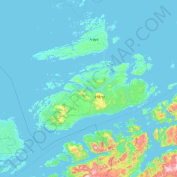
Name: Hitra topographic map, elevation, terrain.
Location: Hitra, Trøndelag, Norway (63.35941 8.10865 63.77365 9.44573)
Average elevation: 48 m
Minimum elevation: -3 m
Maximum elevation: 769 m
Thank you for supporting this site ❤️
Make a donation
Make a donation
Other topographic maps
Click on a map to view its topography, its elevation and its terrain.
Thank you for supporting this site ❤️
Make a donation
Make a donation
Thank you for supporting this site ❤️
Make a donation
Make a donation
Thank you for supporting this site ❤️
Make a donation
Make a donation