Geolocate

Special Region of Yogyakarta topographic map

Interactive map

Click on the map to display elevation.

About this map

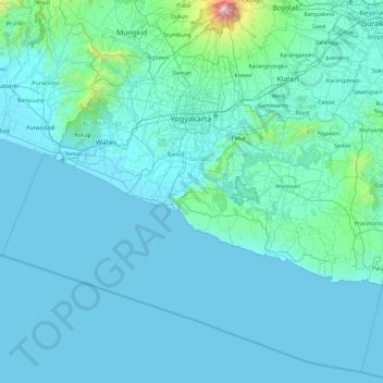
Name: Special Region of Yogyakarta topographic map, elevation, terrain.

Location: Special Region of Yogyakarta, Java, Indonesia (-8.41590 109.90179 -7.54129 110.83869)

Average elevation: 141 m

Minimum elevation: 0 m

Maximum elevation: 2,866 m

Other topographic maps

Click on a map to view its topography, its elevation and its terrain.

Subuk

Indonesia > Bali > Buleleng

Average elevation: 536 m

Nusa Dua

Indonesia > Bali > Badung > Benoa

Average elevation: 21 m

Bencongan

Indonesia > Banten > Tangerang Regency

Average elevation: 27 m

Calaca

Indonesia > North Sulawesi > Manado

Average elevation: 11 m

Mulat

Indonesia > Central Sulawesi

Average elevation: 75 m

sunrise view

Indonesia > West Java > Garut

Average elevation: 781 m

Kalisoro

Indonesia > Central Java > Karanganyar

Average elevation: 1,277 m

Jatiluhur

Indonesia > West Java > Kota Bekasi

Average elevation: 43 m

Bentiang Madomang

Indonesia > West Kalimantan > Landak

Average elevation: 687 m

Gunung Sinabung

Indonesia > North Sumatra > Karo

Average elevation: 1,835 m

Pulau Sanglang Besar

Indonesia > Riau Islands > Karimun

Average elevation: 11 m

Cemoro Lawang

Indonesia > East Java > Cemoro Lawang

Average elevation: 2,171 m

Ponto

Indonesia > North Sulawesi > Ponto

Average elevation: 57 m

Malamala

Indonesia > Southeast Sulawesi > Malamala

Average elevation: 25 m

East Java

Indonesia > East Java

East Java has a tropical monsoon and savanna climate at lower elevation and subtropical at higher elevation. Compared with the western part of Java Island, East Java in general has less rainfall. Average rainfall is 1,900 mm per year, with a rainy season during the 100 days. The average temperature ranges…

Average elevation: 66 m

Gianyar

Indonesia > Bali > Gianyar

Average elevation: 114 m

Gorontalo

Indonesia > Gorontalo

Topographically, the province is relatively low (0–40o), with the elevation ranging between 0–2,400 m (7,900 ft) above sea level. Its coastline length is more than 590 km (370 mi). Counting the Exclusive Economic Zone to the north where Philippines is at the border, the total sea area of the province is…

Average elevation: 123 m

Lampung

Indonesia > Lampung

Average elevation: 99 m

West Sulawesi

Indonesia > West Sulawesi

Average elevation: 219 m

North Maluku

Indonesia > North Maluku

Average elevation: 23 m

West Kalimantan

Indonesia > West Kalimantan

Average elevation: 111 m

Bengkulu

Indonesia > Bengkulu

Average elevation: 146 m

South Sumatra

Indonesia

Average elevation: 114 m

Padang

Indonesia > West Sumatra > Padang

Average elevation: 213 m

Sekaih

Indonesia > West Kalimantan > Sekaih

Average elevation: 43 m

Tebing Tinggi

Indonesia > Jambi

Average elevation: 39 m

Mamasa

Indonesia > West Sulawesi > Mamasa

Average elevation: 1,249 m

Tiakur

Indonesia > Maluku > Tiakur

Average elevation: 9 m

Seruyan River

Indonesia > Central Kalimantan

Average elevation: 4 m

Semarang

Indonesia > Central Java > Semarang > Pleburan

Semarang is located on the northern coast of Java. The city of Semarang is one of the important cities located on the north coast of Java and as the main hub connecting Jakarta and Surabaya, and cities in the southern interior of Java Surakarta and Yogyakarta. Semarang City has a height ranging from 2 m (6.6…

Average elevation: 88 m

Limbung

Indonesia > West Kalimantan > Limbung

Average elevation: 3 m