Geolocate

Region of Murcia topographic map

Interactive map

Click on the map to display elevation.

About this map

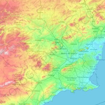
Name: Region of Murcia topographic map, elevation, terrain.

Location: Region of Murcia, Spain (37.37377 -2.34441 38.75509 -0.64716)

Average elevation: 535 m

Minimum elevation: -4 m

Maximum elevation: 2,031 m

Other topographic maps

Click on a map to view its topography, its elevation and its terrain.

Pitera

Spain > Extremadura > Llanos de Olivenza > Barcarrota

Average elevation: 432 m

Masca

Spain > Buenavista del Norte

Masca is a small mountain village on the island of Tenerife. It was originally a Guanche settlement before the Spanish conquest in 1496. The village is now home to around 90 inhabitants. The village lies at an altitude of 650 m in the Macizo de Teno mountains, which extend up to the northwesternmost point of…

Average elevation: 769 m

Chagos

Spain > Cangas del Narcea > Ḷḷarón > La Vilieḷḷa

Average elevation: 958 m

Sierra de Castril

Spain > Andalusia > Comarca de Huéscar > Castril

Average elevation: 1,488 m

La Pola Siero

Spain > Asturias > Siero

Average elevation: 270 m

Cerro de Barbatón

Spain > Castile-La Mancha > Letur

Average elevation: 1,278 m

Cumbre Vieja Nature Park

Spain > El Paso

Average elevation: 1,664 m

Simon

Spain > Valencian Community > La Serranía > Andilla

Average elevation: 1,056 m

Lomo Plata

Spain > Extremadura > La Coronada

Average elevation: 367 m

León

Spain > Castile and León > León

Average elevation: 838 m

Saladillo

Spain > Andalusia > Fuerte del Rey

Average elevation: 295 m

Oribi

Spain > Basque Country > Legazpi

Average elevation: 662 m

A Coruña

Spain > Galicia > A Coruña

Average elevation: 67 m

Torrent del Coll de Clau

Spain > Catalonia > Vallromanes

Average elevation: 259 m

Telle

Spain > Galicia > Telle

Average elevation: 42 m

Vega Larga

Spain > Rioja > Villavelayo

Average elevation: 1,262 m

Barrio Aviche

Spain > Cantabria > Santander > Barrio Aviche

Average elevation: 25 m

Guama

Spain > Santiago del Teide

Average elevation: 247 m

Vargas

Spain > Rioja > Ajamil

Average elevation: 1,167 m

La Gaza

Spain > Navarre > Lerín

Average elevation: 396 m

Cádiz

Spain > Andalusia > Cádiz

The Baluarte de la Candelaria (fortress or stronghold of Candlemas) is a military fortification. Taking advantage of a natural elevation of land, it was constructed in 1672 at the initiative of the governor, Diego Caballero de Illescas. Protected by a seaward-facing wall that had previously served as a…

Average elevation: 3 m

Piedra del Águila

Spain > Andalusia > Beas de Segura

Average elevation: 957 m

Linares

Spain > Cantabria > Castro-Urdiales

Average elevation: 416 m

Cave of Altamira

Spain > Cantabria > Santillana del Mar > Herrán

Average elevation: 116 m

Bruma

Spain > Galicia > Bruma

Average elevation: 404 m

dam wall

Spain > Betancuria

Average elevation: 305 m

Boí

Spain > Catalonia > la Vall de Boí > Boí

Average elevation: 1,590 m

Isla Palma

Spain > Andalusia > Granada > Pinos Puente

Average elevation: 554 m