
Saint Charles County topographic map
Interactive map
Click on the map to display elevation.
Saint Charles County
The highest elevation is 901 feet (275 m) northwest of Augusta near Femme Osage Creek headwaters.
About this map
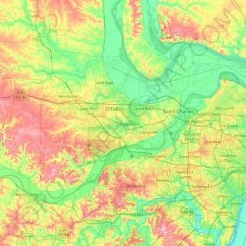
Name: Saint Charles County topographic map, elevation, terrain.
Location: Saint Charles County, Missouri, United States (38.53429 -90.96445 38.96764 -90.10774)
Average elevation: 174 m
Minimum elevation: 115 m
Maximum elevation: 287 m
Other topographic maps
Click on a map to view its topography, its elevation and its terrain.