
Nayarit topographic map
Interactive map
Click on the map to display elevation.
Nayarit
Nayarit's natural vegetation varies with altitude; coastal lowlands and river valleys were, historically, covered with tropical dry forest, containing many native deciduous trees that lost their leaves during the dry seasons. The Sinaloan dry forests now cover the northern coastal lowlands, and extend up the valleys of the San Pedro Mezquital River and the Río Grande de Santiago and its tributaries. The Jalisco dry forests ecoregion covers coastal Nayarit south of San Blas and the Islas Marías.
About this map
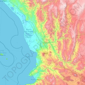
Name: Nayarit topographic map, elevation, terrain.
Location: Nayarit, Mexico (20.60322 -106.70322 23.08450 -103.72090)
Average elevation: 834 m
Minimum elevation: -2 m
Maximum elevation: 3,202 m
Other topographic maps
Click on a map to view its topography, its elevation and its terrain.
Acapulco
Mexico > Guerrero > Acapulco de Juárez
The city, located on the Pacific coast of Mexico in the state of Guerrero, is classified as one of the state's seven regions, dividing the rest of the Guerrero coast into the Costa Grande and the Costa Chica. Forty percent of the municipality is mountainous terrain; another forty percent is semi-flat; and the…
Average elevation: 99 m
Toluca
Mexico > State of Mexico > Toluca
Toluca is located at 2600 meters above sea level, being the highest capital city in Mexico and North America, which makes it temperate throughout the year with average temperatures ranging between 6 and 25 degrees Celsius during spring and summer, and from −5 to 20 degrees Celsius in winter. Its climate is…
Average elevation: 2,729 m
Monterrey
Mexico > Nuevo León > Monterrey
The city of Monterrey is 540 metres (1,770 ft) above sea level in the northeastern state of Nuevo León. Monterrey translated literally from Spanish to English is "King Mount" or "King Mountain", and folk etymology claims that this refers to the city's topography and the large mountains that surround it…
Average elevation: 753 m
Hermosillo
Mexico > Sonora > Hermosillo
The Cerro de la Campana mountain is one of the symbols of Hermosillo. Its summit is 350 metres (1,150 ft) above the valley floor and contains a lookout called El Caracol, which was inaugurated in 1909. There are two theories as to the origin of the mountain's name. One states that it is from a peculiar…
Average elevation: 248 m
Ciudad Juárez
Due to its location in the Chihuahuan Desert and high altitude, Ciudad Juárez has a cold desert climate (Köppen: BWk). Seasons are distinct, with hot summers, mild springs and autumns, and cold winters. Summer average high is 35 °C (95 °F) with lows of 21 °C (70 °F). Winter highs average 14 °C (57 °F)…
Average elevation: 1,228 m
Tuxtla Gutiérrez
Mexico > Chiapas > Tuxtla Gutiérrez
On the edge of the city is the El Zapotal Ecological Reserve, best known as the home of the Zoológico Miguel Alvarez del Toro Zoo, often referred to as the ZooMAT. The zoo covers 100 hectares and was founded by Miguel Alvarez del Toro in 1942. He was also the director for over fifty years. ZooMAT is…
Average elevation: 817 m
Guadalajara
Mexico > Jalisco > Guadalajara
Under the Köppen climate classification, Guadalajara has a humid subtropical climate (Cwa), a temperate climate that is quite close to a tropical climate, featuring dry warm winters and wet, mildly hot summers. Guadalajara's climate is influenced by its high altitude and the general seasonality of…
Average elevation: 1,572 m
Saltillo
El Cerro del Pueblo (The Town Hill) and its 4-metre (13 ft) cross overlook the city. The city's elevation makes it colder and windier than the neighboring city of Monterrey. Saltillo lies in the Chihuahuan Desert near the city of Arteaga. The city is flanked by the Zapalinamé mountains, which are part of the…
Average elevation: 1,857 m
Aguascalientes City
Mexico > Aguascalientes > Municipio de Aguascalientes
The Aguascalientes Bicentenary Velodrome, designed by Peter Junek, hosted the 2010 Pan American Track Championships. At an elevation of 1887m, the Velodrome is a frequent location for attempts at breaking the Cycling Hour Record.
Average elevation: 1,956 m
Tijuana
Mexico > Baja California > Municipio de Tijuana
Housing development in the Tijuana Hills has led to eradication of many seasonal mountain streams. This lack of natural drainage makes places within the city vulnerable to landslides during the rainy season. The varied terrain of Tijuana gives the city elevation extremes that range from sea level to 790 meters…
Average elevation: 141 m
Villahermosa
Villahermosa is located in the southeast of Mexico between the rivers Grijalva and Carrizal. The average elevation of the city is 10 meters above sea level. The city also has several lagoons, the largest and most important of them being La Laguna de las Ilusiones (Illusions Lagoon).
Average elevation: 9 m
Pachuca
Mexico > Hidalgo > Pachuca de Soto
Pachuca has a semi-arid climate (Köppen climate classification BSk). The climate is cool with high rainfall and occasional hail during the summer months and dry conditions during the winter. The coldest month is January, with an average high of 20 °C (68 °F) and an average low of 3 °C (37 °F). Winter…
Average elevation: 2,459 m
Matehuala
Mexico > San Luis Potosi > Matehuala
Matehuala is a city in the Mexican state of San Luis Potosí, situated at an elevation of about 1,500 m. Matehuala is also the municipal seat of the municipality of the same name, located in the northern part of the state, on the border with the southwestern corner of Nuevo León. The municipality of Matehuala…
Average elevation: 1,754 m
Ciudad Victoria
Mexico > Tamaulipas > Victoria
Ciudad Victoria has a climate on the border of humid subtropical (Köppen Cfa/Cwa) and hot semi-arid (BSh). Its weather is characterised by short warm winters and long hot to sweltering summers. Temperatures rarely drop below 0 °C (32 °F) — the lowest recorded temperature was −6 °C (21.2 °F) and the…
Average elevation: 518 m
Tepic
Mexico > Nayarit > Municipio de Tepic
Located in the central part of the state, it stands at an altitude of 915 metres (3,002 ft) above sea level, on the banks of the Río Mololoa and the Río Tepic, approximately 225 kilometres (140 mi) north-west of Guadalajara, Jalisco. Nearby are the extinct Sangangüey volcano and its crater lake. Tepic is…
Average elevation: 921 m