
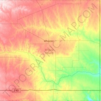
Wheeler County topographic map
Interactive map
Click on the map to display elevation.
About this map
Name: Wheeler County topographic map, elevation, terrain.
Location: Wheeler County, Texas, United States (35.18273 -100.54004 35.61968 -100.00027)
Average elevation: 747 m
Minimum elevation: 599 m
Maximum elevation: 913 m
Other topographic maps
Click on a map to view its topography, its elevation and its terrain.
Plano
United States > Texas > Collin County > Plano
At first, Plano's population grew slowly, reaching 1,304 in 1900 and 3,695 in 1960. By 1970, Plano began to feel some of the boom its neighbors had experienced after World War II. A series of public works projects and a change in taxes that removed the farming community from the town helped increase the…
Average elevation: 181 m
Austin
United States > Texas > Travis County > Austin
The elevation of Austin varies from 425 feet (130 m) to approximately 1,000 feet (305 m) above sea level. Due to the fact it straddles the Balcones Fault, much of the eastern part of the city is flat, with heavy clay and loam soils, whereas the western part and western suburbs consist of rolling hills on the…
Average elevation: 203 m