
Mackenzie topographic map
Interactive map
Click on the map to display elevation.
About this map
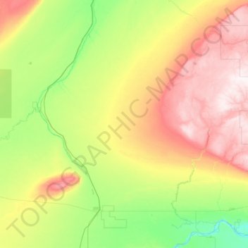
Name: Mackenzie topographic map, elevation, terrain.
Location: Mackenzie, Alberta, Canada (58.32329 -117.50865 59.60329 -116.22865)
Average elevation: 458 m
Minimum elevation: 244 m
Maximum elevation: 996 m
Other topographic maps
Click on a map to view its topography, its elevation and its terrain.
Calgary
Calgary experiences a semi-monsoonal humid continental climate (Köppen climate classification Dwb, Trewartha climate classification Dcbo) within eastern parts of the city and a subarctic climate (Köppen Dwc, Trewartha Eolo) within western parts of the city, largely due to an increase in elevation. However,…
Average elevation: 1,104 m
Edmonton
Edmonton is on the North Saskatchewan River, at an elevation of 671 m (2,201 ft). It is North America's northernmost city with a population over one million. It is south of Alberta's geographic centre, which is near the Hamlet of Fort Assiniboine. The terrain in and around Edmonton is generally flat to gently…
Average elevation: 690 m