
Punjab topographic map
Interactive map
Click on the map to display elevation.
About this map
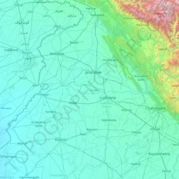
Name: Punjab topographic map, elevation, terrain.
Location: Punjab, India (29.54294 73.87983 32.51118 76.93906)
Average elevation: 477 m
Minimum elevation: 170 m
Maximum elevation: 6,027 m
Punjab is in northwestern India and has a total area of 50,362 square kilometres (19,445 sq mi). Punjab is bordered by Pakistan's Punjab province on the west, Jammu and Kashmir on the north, Himachal Pradesh on the northeast and Haryana and Rajasthan on the south. Most of Punjab lies in a fertile, alluvial plain with perennial rivers and an extensive irrigation canal system. A belt of undulating hills extends along the northeastern part of the state at the foot of the Himalayas. Its average elevation is 300 metres (980 ft) above sea level, with a range from 180 metres (590 ft) in the southwest to more than 500 metres (1,600 ft) around the northeast border. The southwest of the state is semi-arid, eventually merging into the Thar Desert. Of the five Punjab rivers, three—Sutlej, Beas and Ravi—flow through the Indian state. The Sutlej and Ravi define parts of the international border with Pakistan.
Other topographic maps
Click on a map to view its topography, its elevation and its terrain.
Taleni
India > Madhya Pradesh > Polayakala Tahsil
Taleni, Polayakala Tahsil, Shajapur District, Madhya Pradesh, 465113, India
Average elevation: 462 m
Gaduka
India > Gujarat > Jamnagar Taluka
Gaduka, Jamnagar Taluka, Jamnagar District, Gujarat, India
Average elevation: 17 m
Ward 11
Ward 11, Chandigarh, Chandigarh District, Chandigarh, India
Average elevation: 328 m
Kanpur Dehat District
Kanpur Dehat District, Uttar Pradesh, India
Average elevation: 132 m
Bengaluru
India > Karnataka > Bangalore North
Bengaluru, Bangalore North, Bengaluru Urban, Karnataka, India
Average elevation: 886 m
Car Nicobar
India > Andaman and Nicobar Islands
Car Nicobar, Nicobar District, Andaman and Nicobar Islands, India
Average elevation: 11 m
Coronation Park
India > Delhi > Model Town Tehsil
Coronation Park, Model Town Tehsil, North Delhi District, Delhi, India
Average elevation: 209 m
Bangalore South
Bangalore South, Bengaluru Urban, Karnataka, India
Average elevation: 847 m
Eastern West Khasi Hills District
Eastern West Khasi Hills District, Meghalaya, 793120, India
Average elevation: 1,176 m
Amber
India > Rajasthan > Amber Tehsil > Jaipur Municipal Corporation
Amber, Jaipur Municipal Corporation, Amber Tehsil, Jaipur District, Rajasthan, 303101, India
Average elevation: 468 m
Ankleshwar
India > Gujarat > Ankleshwar Taluka
Ankleshwar, Ankleshwar Taluka, Bharuch District, Gujarat, India
Average elevation: 17 m
Sundargarh
India > Odisha > Sundargarh Town
Sundargarh, Sundargarh Town, Sundargarh District, Odisha, 770001, India
Average elevation: 243 m
Khasi Hills
India > Meghalaya > Mawshynrut
Khasi Hills, Mawshynrut, West Khasi Hills District, Meghalaya, India
Average elevation: 349 m
Sullurpeta
India > Andhra Pradesh > Sullurpeta
Sullurpeta, Tirupati District, Andhra Pradesh, 524121, India
Average elevation: 4 m
Vinchhiya
India > Gujarat > Vinchhiya Taluka
Vinchhiya, Vinchhiya Taluka, Rajkot District, Gujarat, 360050, India
Average elevation: 173 m
South Lhonak Glacier
India > Sikkim > Chungthang
South Lhonak Glacier, Chungthang, Mangan District, Sikkim, India
Average elevation: 5,830 m
New Town
New Town, North 24 Parganas District, West Bengal, 700161, India
Average elevation: 5 m
Khutala
India > Maharashtra > Chimur Taluka
Khutala, Chimur Taluka, Chandrapur District, Maharashtra, 442904, India
Average elevation: 225 m
Ward 91
India > Tamil Nadu > Ambattur
Ward 91, Zone 7 Ambattur, Ambattur, Thiruvallur District, Tamil Nadu, 600037, India
Average elevation: 15 m
Nicobar Islands
India > Andaman and Nicobar Islands > Great Nicobar
Nicobar Islands, Great Nicobar, Nicobar, Andaman and Nicobar Islands, India
Average elevation: 2 m
Pallavaram
Pallavaram, Chengalpattu District, Tamil Nadu, India
Average elevation: 21 m
Dantiwada
India > Gujarat > Dantiwada Taluka
Dantiwada, Dantiwada Taluka, Banas Kantha District, Gujarat, 385505, India
Average elevation: 168 m
Sriperumbudur
Sriperumbudur, Kanchipuram District, Tamil Nadu, India
Average elevation: 48 m
Ward 92
India > Tamil Nadu > Ambattur
Ward 92, Zone 7 Ambattur, Ambattur, Thiruvallur District, Tamil Nadu, India
Average elevation: 15 m
Hassan
India > Karnataka > Hasana taluk
Hassan, Hasana taluk, Hassan district, Karnataka, 573201, India
Average elevation: 949 m
Leh
India > Ladakh > Leh Tehsil
Leh, Leh Tehsil, Leh district, Ladakh, India
Average elevation: 3,653 m
Bengaluru
India > Karnataka > Bangalore North > Bengaluru
Bengaluru, Bangalore North, Bangalore Urban, Karnataka, 560001, India
Average elevation: 879 m
Vasana
India > Karnataka > Harihara taluku > Vasana
Vasana, Harihara taluku, Davanagere District, Karnataka, 581119, India
Average elevation: 543 m
Ward 37
India > Odisha > Bhubaneswar (M.Corp.) > Bhubaneswar Municipal Corporation
Ward 37, South West Zone, Bhubaneswar Municipal Corporation, Bhubaneswar (M.Corp.), Khordha, Odisha, 751001, India
Average elevation: 51 m