
Make a donation
Kuala Lumpur topographic map
Click on the map to display elevation.
Make a donation
Kuala Lumpur
Located in the centre of Selangor state, Kuala Lumpur was a territory of Selangor State Government. In 1974, Kuala Lumpur was split off from Selangor to form the first Federal Territory governed directly by the Malaysian federal government. Its location in the most developed state on the west coast of peninsular Malaysia, which has a wider stretch of flat land than the east coast, has helped it develop faster than other cities in Malaysia. The municipality covers an area of 243 km2 (94 sq mi), with an average elevation of 81.95 m (268 ft 10 in) highest point being Bukit Nanas at 94 meters above sea level.
Make a donation
About this map
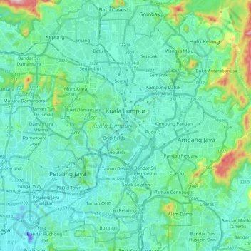
Name: Kuala Lumpur topographic map, elevation, terrain.
Location: Kuala Lumpur, Malaysia (3.03343 101.61514 3.24455 101.75849)
Average elevation: 80 m
Minimum elevation: -46 m
Maximum elevation: 506 m
Make a donation
Other topographic maps
Click on a map to view its topography, its elevation and its terrain.
Pahang
The highest peak, Mount Tahan, reaches 2,187 m (7,175 ft) in elevation, which is also the highest point in the Peninsular Malaysia. The climate is temperate enough to have distinct temperature variations year round, and much of the highlands are covered with tropical rainforest. Pahang is home to Malaysia's…
Average elevation: 90 m
Make a donation
Make a donation
Make a donation
Make a donation
Hulu Kelang
Malaysia > Selangor > Ampang Jaya Municipal Council > Hulu Kelang
Average elevation: 147 m
Make a donation