
Biella topographic map
Interactive map
Click on the map to display elevation.
About this map
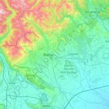
Name: Biella topographic map, elevation, terrain.
Location: Biella, Piemont, Italy (45.37609 7.88146 45.75764 8.32791)
Average elevation: 668 m
Minimum elevation: 140 m
Maximum elevation: 3,061 m
Other topographic maps
Click on a map to view its topography, its elevation and its terrain.
Madonna del Sasso
Italy > Piemont > Madonna del Sasso
Madonna del Sasso, VB, Piemont, 28894, Italy
Average elevation: 783 m
Domodossola
Italy > Piemont > Domodossola
Domodossola, VB, Piemont, 28845, Italy
Average elevation: 837 m
Ghiacciaio del Belvedere
Ghiacciaio del Belvedere, bivacco Marinelli, Macugnaga, VB, Piemont, Italy
Average elevation: 2,971 m
Western Alps
Italy > Piemont > Ceppo Morelli
Western Alps, Ceppo Morelli, VB, Piemont, 28876, Italy
Average elevation: 2,662 m