
Banna topographic map
Interactive map
Click on the map to display elevation.
About this map
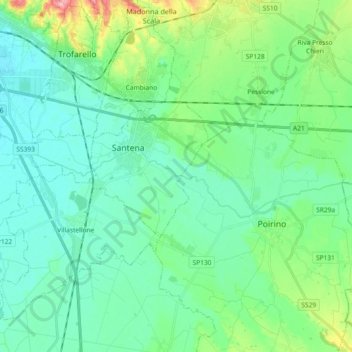
Name: Banna topographic map, elevation, terrain.
Location: Banna, Torino, Piemont, 10026, Italy (44.92321 7.70520 44.95362 7.88899)
Average elevation: 248 m
Minimum elevation: 221 m
Maximum elevation: 343 m
Other topographic maps
Click on a map to view its topography, its elevation and its terrain.
Madonna del Sasso
Italy > Piemont > Madonna del Sasso
Madonna del Sasso, VB, Piemont, 28894, Italy
Average elevation: 783 m
Domodossola
Italy > Piemont > Domodossola
Domodossola, VB, Piemont, 28845, Italy
Average elevation: 837 m
Ghiacciaio del Belvedere
Ghiacciaio del Belvedere, bivacco Marinelli, Macugnaga, VB, Piemont, Italy
Average elevation: 2,971 m
Western Alps
Italy > Piemont > Ceppo Morelli
Western Alps, Ceppo Morelli, VB, Piemont, 28876, Italy
Average elevation: 2,662 m