
Make a donation
Reit River topographic map
Click on the map to display elevation.
Make a donation
About this map
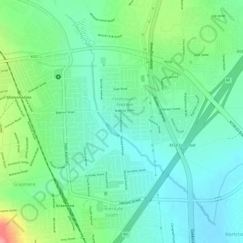
Name: Reit River topographic map, elevation, terrain.
Average elevation: 1,603 m
Minimum elevation: 1,570 m
Maximum elevation: 1,677 m
Make a donation
Other topographic maps
Click on a map to view its topography, its elevation and its terrain.
Diepsloot
South Africa > Gauteng > City of Johannesburg Metropolitan Municipality > Diepsloot
Average elevation: 1,407 m
Johannesburg Ward 88
South Africa > Gauteng > City of Johannesburg Metropolitan Municipality
Average elevation: 1,643 m
Johannesburg Ward 69
South Africa > Gauteng > City of Johannesburg Metropolitan Municipality
Average elevation: 1,715 m
Johannesburg Ward 68
South Africa > Gauteng > City of Johannesburg Metropolitan Municipality
Average elevation: 1,695 m
Make a donation
Melville Koppies East
South Africa > Gauteng > City of Johannesburg Metropolitan Municipality > Johannesburg
Average elevation: 1,669 m
Johannesburg Ward 89
South Africa > Gauteng > City of Johannesburg Metropolitan Municipality
Average elevation: 1,637 m
Johannesburg Ward 58
South Africa > Gauteng > City of Johannesburg Metropolitan Municipality
Average elevation: 1,725 m
Rose Gardens
South Africa > Gauteng > City of Johannesburg Metropolitan Municipality > Johannesburg
Average elevation: 1,613 m
Make a donation