
Make a donation
Jukskei River topographic map
Click on the map to display elevation.
Make a donation
About this map
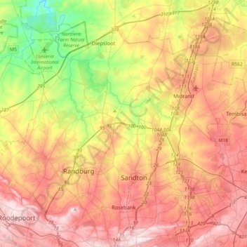
Name: Jukskei River topographic map, elevation, terrain.
Average elevation: 1,528 m
Minimum elevation: 1,230 m
Maximum elevation: 1,809 m
Make a donation
Other topographic maps
Click on a map to view its topography, its elevation and its terrain.
Johannesburg
South Africa > Gauteng > City of Johannesburg Metropolitan Municipality
Johannesburg is located in the eastern plateau area of South Africa known as the Highveld, at an elevation of 1,753 metres (5,751 ft). The former Central Business District is located on the southern side of the prominent ridge called the Witwatersrand (English: White Water's Ridge) and the terrain falls to the…
Average elevation: 1,615 m
Soweto
South Africa > Gauteng > City of Johannesburg Metropolitan Municipality
Average elevation: 1,638 m
Johannesburg
South Africa > Gauteng > City of Johannesburg Metropolitan Municipality
Johannesburg is located in the eastern plateau area of South Africa known as the Highveld, at an elevation of 1,753 metres (5,751 ft). The former Central Business District is located on the southern side of the prominent ridge called the Witwatersrand (English: White Water's Ridge) and the terrain falls to the…
Average elevation: 1,615 m
Midrand
South Africa > Gauteng > City of Johannesburg Metropolitan Municipality
Average elevation: 1,542 m
Make a donation
Tshepisong
South Africa > Gauteng > City of Johannesburg Metropolitan Municipality
Average elevation: 1,678 m
Roodepoort
South Africa > Gauteng > City of Johannesburg Metropolitan Municipality
Average elevation: 1,593 m
Soweto
South Africa > Gauteng > City of Johannesburg Metropolitan Municipality
Average elevation: 1,638 m
City of Johannesburg Metropolitan Municipality
South Africa > Gauteng > City of Johannesburg Metropolitan Municipality
Average elevation: 1,615 m
Make a donation
Randburg
South Africa > Gauteng > City of Johannesburg Metropolitan Municipality
Average elevation: 1,567 m
Sandton
South Africa > Gauteng > City of Johannesburg Metropolitan Municipality
Average elevation: 1,583 m
Lenasia
South Africa > Gauteng > City of Johannesburg Metropolitan Municipality
Average elevation: 1,590 m
Randburg
South Africa > Gauteng > City of Johannesburg Metropolitan Municipality
Average elevation: 1,567 m
Make a donation
Johannesburg
South Africa > Gauteng > City of Johannesburg Metropolitan Municipality
Johannesburg is located in the eastern plateau area of South Africa known as the Highveld, at an elevation of 1,753 metres (5,751 ft). The former Central Business District is located on the southern side of the prominent ridge called the Witwatersrand (English: White Water's Ridge) and the terrain falls to the…
Average elevation: 1,615 m
Emmarentia Dam
South Africa > Gauteng > City of Johannesburg Metropolitan Municipality > Johannesburg
Average elevation: 1,611 m
Ennerdale
South Africa > Gauteng > City of Johannesburg Metropolitan Municipality
Average elevation: 1,630 m
Tshepisong
South Africa > Gauteng > City of Johannesburg Metropolitan Municipality
Average elevation: 1,678 m
Make a donation
Klipriviersberg Nature Reserve
South Africa > Gauteng > City of Johannesburg Metropolitan Municipality > Johannesburg
Average elevation: 1,634 m
Delta Park
South Africa > Gauteng > City of Johannesburg Metropolitan Municipality > Rosebank
Average elevation: 1,588 m
Emmarentia Dog Park
South Africa > Gauteng > City of Johannesburg Metropolitan Municipality > Johannesburg
Average elevation: 1,641 m
Rosebank
South Africa > Gauteng > City of Johannesburg Metropolitan Municipality
Average elevation: 1,638 m
Make a donation
Zoo Lake
South Africa > Gauteng > City of Johannesburg Metropolitan Municipality > Rosebank
Average elevation: 1,647 m
Thokoza Park
South Africa > Gauteng > City of Johannesburg Metropolitan Municipality > Soweto
Average elevation: 1,604 m
Leratong Village
South Africa > Gauteng > City of Johannesburg Metropolitan Municipality
Average elevation: 1,688 m
Roodepoort
South Africa > Gauteng > City of Johannesburg Metropolitan Municipality
Average elevation: 1,612 m
Make a donation
Unaville AH
South Africa > Gauteng > City of Johannesburg Metropolitan Municipality
Average elevation: 1,619 m
George Hay Park
South Africa > Gauteng > City of Johannesburg Metropolitan Municipality > Johannesburg
Average elevation: 1,648 m
Johannesburg Botanical Gardens
South Africa > Gauteng > City of Johannesburg Metropolitan Municipality > Johannesburg
Average elevation: 1,633 m
Emmarentia Fountain
South Africa > Gauteng > City of Johannesburg Metropolitan Municipality > Johannesburg
Average elevation: 1,612 m
Make a donation
Jukskei Park
South Africa > Gauteng > City of Johannesburg Metropolitan Municipality > Randburg
Average elevation: 1,427 m
Victory Park
South Africa > Gauteng > City of Johannesburg Metropolitan Municipality > Johannesburg
Average elevation: 1,597 m
Thokoza Park
South Africa > Gauteng > City of Johannesburg Metropolitan Municipality > Soweto
Average elevation: 1,604 m
Kew
South Africa > Gauteng > City of Johannesburg Metropolitan Municipality
Average elevation: 1,601 m
Make a donation
Diepsloot
South Africa > Gauteng > City of Johannesburg Metropolitan Municipality > Diepsloot
Average elevation: 1,407 m
Soweto
South Africa > Gauteng > City of Johannesburg Metropolitan Municipality
Average elevation: 1,638 m
Klip River
South Africa > Gauteng > City of Johannesburg Metropolitan Municipality
Average elevation: 1,535 m
Lenasia
South Africa > Gauteng > City of Johannesburg Metropolitan Municipality
Average elevation: 1,590 m
Make a donation
Soweto
South Africa > Gauteng > City of Johannesburg Metropolitan Municipality
Average elevation: 1,638 m
Ennerdale
South Africa > Gauteng > City of Johannesburg Metropolitan Municipality
Average elevation: 1,630 m
Midrand
South Africa > Gauteng > City of Johannesburg Metropolitan Municipality
Average elevation: 1,542 m
Johannesburg
South Africa > Gauteng > City of Johannesburg Metropolitan Municipality
Johannesburg is located in the eastern plateau area of South Africa known as the Highveld, at an elevation of 1,753 metres (5,751 ft). The former Central Business District is located on the southern side of the prominent ridge called the Witwatersrand (English: White Water's Ridge) and the terrain falls to the…
Average elevation: 1,615 m
Make a donation
Roodepoort
South Africa > Gauteng > City of Johannesburg Metropolitan Municipality
Average elevation: 1,593 m
Roodepoort
South Africa > Gauteng > City of Johannesburg Metropolitan Municipality
Average elevation: 1,593 m
Rosebank
South Africa > Gauteng > City of Johannesburg Metropolitan Municipality
Average elevation: 1,638 m
Emmarentia Dam
South Africa > Gauteng > City of Johannesburg Metropolitan Municipality > Johannesburg
Average elevation: 1,611 m
Make a donation
Soweto
South Africa > Gauteng > City of Johannesburg Metropolitan Municipality
Average elevation: 1,638 m
Johannesburg
South Africa > Gauteng > City of Johannesburg Metropolitan Municipality
Johannesburg is located in the eastern plateau area of South Africa known as the Highveld, at an elevation of 1,753 metres (5,751 ft). The former Central Business District is located on the southern side of the prominent ridge called the Witwatersrand (English: White Water's Ridge) and the terrain falls to the…
Average elevation: 1,615 m
Roodepoort
South Africa > Gauteng > City of Johannesburg Metropolitan Municipality
Average elevation: 1,594 m
Midrand
South Africa > Gauteng > City of Johannesburg Metropolitan Municipality
Average elevation: 1,542 m
Make a donation
Ennerdale
South Africa > Gauteng > City of Johannesburg Metropolitan Municipality
Average elevation: 1,630 m
Sandton
South Africa > Gauteng > City of Johannesburg Metropolitan Municipality
Average elevation: 1,583 m
Alexander Park
South Africa > Gauteng > City of Johannesburg Metropolitan Municipality > Johannesburg
Average elevation: 1,709 m
Johannesburg
South Africa > Gauteng > City of Johannesburg Metropolitan Municipality
Johannesburg is located in the eastern plateau area of South Africa known as the Highveld, at an elevation of 1,753 metres (5,751 ft). The former Central Business District is located on the southern side of the prominent ridge called the Witwatersrand (English: White Water's Ridge) and the terrain falls to the…
Average elevation: 1,615 m
Make a donation
Randburg
South Africa > Gauteng > City of Johannesburg Metropolitan Municipality
Average elevation: 1,567 m
Lenasia
South Africa > Gauteng > City of Johannesburg Metropolitan Municipality
Average elevation: 1,590 m
Soweto
South Africa > Gauteng > City of Johannesburg Metropolitan Municipality
Average elevation: 1,638 m
Soweto
South Africa > Gauteng > City of Johannesburg Metropolitan Municipality
Average elevation: 1,638 m
Make a donation
Randburg
South Africa > Gauteng > City of Johannesburg Metropolitan Municipality
Average elevation: 1,567 m
Zoo Lake
South Africa > Gauteng > City of Johannesburg Metropolitan Municipality > Rosebank
Average elevation: 1,647 m
Johannesburg
South Africa > Gauteng > City of Johannesburg Metropolitan Municipality
Johannesburg is located in the eastern plateau area of South Africa known as the Highveld, at an elevation of 1,753 metres (5,751 ft). The former Central Business District is located on the southern side of the prominent ridge called the Witwatersrand (English: White Water's Ridge) and the terrain falls to the…
Average elevation: 1,615 m
Make a donation
Roodepoort
South Africa > Gauteng > City of Johannesburg Metropolitan Municipality
Average elevation: 1,612 m
Sandton
South Africa > Gauteng > City of Johannesburg Metropolitan Municipality
Average elevation: 1,583 m
Sandton
South Africa > Gauteng > City of Johannesburg Metropolitan Municipality
Average elevation: 1,583 m
Sandton
South Africa > Gauteng > City of Johannesburg Metropolitan Municipality
Average elevation: 1,583 m
Make a donation
Soweto
South Africa > Gauteng > City of Johannesburg Metropolitan Municipality
Average elevation: 1,638 m
Randburg
South Africa > Gauteng > City of Johannesburg Metropolitan Municipality
Average elevation: 1,567 m
Lenasia
South Africa > Gauteng > City of Johannesburg Metropolitan Municipality
Average elevation: 1,590 m
Delta Park
South Africa > Gauteng > City of Johannesburg Metropolitan Municipality > Rosebank
Average elevation: 1,588 m
Make a donation
Johannesburg
South Africa > Gauteng > City of Johannesburg Metropolitan Municipality
Johannesburg is located in the eastern plateau area of South Africa known as the Highveld, at an elevation of 1,753 metres (5,751 ft). The former Central Business District is located on the southern side of the prominent ridge called the Witwatersrand (English: White Water's Ridge) and the terrain falls to the…
Average elevation: 1,615 m
Rosebank
South Africa > Gauteng > City of Johannesburg Metropolitan Municipality
Average elevation: 1,638 m
Emmarentia Dam
South Africa > Gauteng > City of Johannesburg Metropolitan Municipality > Johannesburg
Average elevation: 1,611 m
Soweto
South Africa > Gauteng > City of Johannesburg Metropolitan Municipality
Average elevation: 1,638 m
Make a donation
Midrand
South Africa > Gauteng > City of Johannesburg Metropolitan Municipality
Average elevation: 1,542 m
Johannesburg
South Africa > Gauteng > City of Johannesburg Metropolitan Municipality
Johannesburg is located in the eastern plateau area of South Africa known as the Highveld, at an elevation of 1,753 metres (5,751 ft). The former Central Business District is located on the southern side of the prominent ridge called the Witwatersrand (English: White Water's Ridge) and the terrain falls to the…
Average elevation: 1,615 m
Sandton
South Africa > Gauteng > City of Johannesburg Metropolitan Municipality
Average elevation: 1,583 m
Roodepoort
South Africa > Gauteng > City of Johannesburg Metropolitan Municipality
Average elevation: 1,594 m
Make a donation
Eldoret Park
South Africa > Gauteng > City of Johannesburg Metropolitan Municipality > Sandton
Average elevation: 1,440 m
Sandton
South Africa > Gauteng > City of Johannesburg Metropolitan Municipality
Average elevation: 1,583 m
Midrand
South Africa > Gauteng > City of Johannesburg Metropolitan Municipality
Average elevation: 1,542 m
Darrenwood Park
South Africa > Gauteng > City of Johannesburg Metropolitan Municipality > Johannesburg
Average elevation: 1,598 m
Make a donation
Johannesburg
South Africa > Gauteng > City of Johannesburg Metropolitan Municipality
Johannesburg is located in the eastern plateau area of South Africa known as the Highveld, at an elevation of 1,753 metres (5,751 ft). The former Central Business District is located on the southern side of the prominent ridge called the Witwatersrand (English: White Water's Ridge) and the terrain falls to the…
Average elevation: 1,615 m
Roodepoort
South Africa > Gauteng > City of Johannesburg Metropolitan Municipality
Average elevation: 1,612 m
City of Johannesburg Metropolitan Municipality
South Africa > Gauteng > City of Johannesburg Metropolitan Municipality
Average elevation: 1,615 m
Roodepoort
South Africa > Gauteng > City of Johannesburg Metropolitan Municipality
Average elevation: 1,593 m
Make a donation
Chartwell Gardens
South Africa > Gauteng > City of Johannesburg Metropolitan Municipality > Johannesburg
Average elevation: 1,703 m
Roodepoort
South Africa > Gauteng > City of Johannesburg Metropolitan Municipality
Average elevation: 1,612 m