
Nornes topographic map
Interactive map
Click on the map to display elevation.
About this map
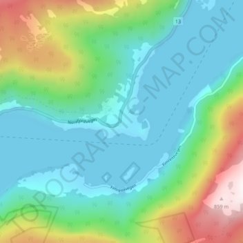
Name: Nornes topographic map, elevation, terrain.
Location: Nornes, Sogndal, Vestland, 6859, Norvège (61.14051 6.96802 61.18051 7.00802)
Average elevation: 224 m
Minimum elevation: -1 m
Maximum elevation: 872 m
Other topographic maps
Click on a map to view its topography, its elevation and its terrain.
Preikestolen
Preikestolen, Osterøy, Vestland, 5284, Norvège
Average elevation: 262 m
Vossavangen
Norvège > Vestland > Vossavangen
Vossavangen, Voss herad, Vestland, 5701, Norvège
Average elevation: 352 m