
Flåm topographic map
Interactive map
Click on the map to display elevation.
About this map
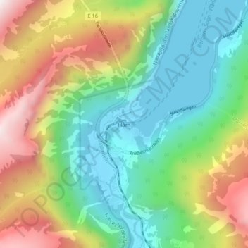
Name: Flåm topographic map, elevation, terrain.
Location: Flåm, Aurland, Vestland, 5743, Norvège (60.84245 7.09374 60.88245 7.13374)
Average elevation: 460 m
Minimum elevation: -1 m
Maximum elevation: 1,313 m
Other topographic maps
Click on a map to view its topography, its elevation and its terrain.
Preikestolen
Preikestolen, Osterøy, Vestland, 5284, Norvège
Average elevation: 262 m
Vossavangen
Norvège > Vestland > Vossavangen
Vossavangen, Voss herad, Vestland, 5701, Norvège
Average elevation: 352 m