
Make a donation
Ngqushwa Local Municipality topographic map
Click on the map to display elevation.
Make a donation
About this map
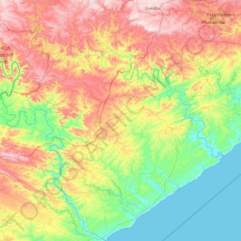
Name: Ngqushwa Local Municipality topographic map, elevation, terrain.
Average elevation: 232 m
Minimum elevation: -2 m
Maximum elevation: 620 m
Make a donation
Other topographic maps
Click on a map to view its topography, its elevation and its terrain.
Marshstrand
South Africa > Eastern Cape > Amathole District Municipality > Great Kei Local Municipality
Average elevation: 37 m
Cathcart
South Africa > Eastern Cape > Amathole District Municipality > Amahlathi Local Municipality
Average elevation: 1,196 m
Gcuwa River
South Africa > Eastern Cape > Amathole District Municipality > Mnquma Local Municipality > Butterworth
Average elevation: 565 m
Bedford
South Africa > Eastern Cape > Amathole District Municipality > Nxuba Local Municipality
Average elevation: 850 m
Make a donation
Keiskammahoek
South Africa > Eastern Cape > Amathole District Municipality > Amahlathi Local Municipality
Average elevation: 669 m
Mbiza
South Africa > Eastern Cape > Amathole District Municipality > Mnquma Local Municipality
Average elevation: 755 m
Chintsa
South Africa > Eastern Cape > Amathole District Municipality > Great Kei Local Municipality
Average elevation: 44 m
Kubusi River
South Africa > Eastern Cape > Amathole District Municipality > Amahlathi Local Municipality
Average elevation: 799 m
Make a donation
Cumakala
South Africa > Eastern Cape > Amathole District Municipality > Amahlathi Local Municipality > Cumakala
Average elevation: 836 m
Ngqatyana
South Africa > Eastern Cape > Amathole District Municipality > Mbhashe Local Municipality
Average elevation: 268 m
Ntaba kaNdoda Peak
South Africa > Eastern Cape > Amathole District Municipality > Amahlathi Local Municipality
Average elevation: 747 m
Kat River
South Africa > Eastern Cape > Amathole District Municipality > Nkonkobe Local Municipality
Average elevation: 326 m
Make a donation