
Elbow Lake topographic map
Interactive map
Click on the map to display elevation.
About this map
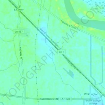
Name: Elbow Lake topographic map, elevation, terrain.
Location: Elbow Lake, Rapides Parish, Louisiana, USA (31.17416 -92.34800 31.20496 -92.33468)
Average elevation: 19 m
Minimum elevation: 14 m
Maximum elevation: 26 m
Other topographic maps
Click on a map to view its topography, its elevation and its terrain.
Fontainebleau State Park
USA > Louisiana > Big Branch
Fontainebleau State Park, Big Branch, St. Tammany Parish, Louisiana, USA
Average elevation: 5 m
Saint Johns Island
Saint Johns Island, Cameron Parish, Louisiana, 70631, USA
Average elevation: 1 m
Grand Pass
Grand Pass, Plaquemines Parish, Louisiana, 70091, USA
Average elevation: 0 m
Scarborough Lake
USA > Louisiana > Hickory Hills
Scarborough Lake, Troy Drive, Hickory Hills, St. Tammany Parish, Louisiana, 70461, USA
Average elevation: 7 m
Current River
Current River, St. Tammany Parish, Louisiana, 70452, USA
Average elevation: 8 m