
Kehlen topographic map
Interactive map
Click on the map to display elevation.
About this map
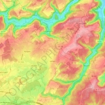
Name: Kehlen topographic map, elevation, terrain.
Location: Kehlen, Canton Capellen, Luxembourg (49.64393 5.97751 49.70365 6.09225)
Average elevation: 327 m
Minimum elevation: 232 m
Maximum elevation: 395 m
Elle a une superficie de 2 818 ha et compte environ 4 800 habitants. La superficie boisée est de 454 ha et l’altitude varie entre 242 et 389 m.
Other topographic maps
Click on a map to view its topography, its elevation and its terrain.
Eischen
Luxembourg > Canton Capellen > Habscht
Eischen, Habscht, Canton Capellen, Luxembourg
Average elevation: 339 m
Capellen
Luxembourg > Canton Capellen > Mamer
Capellen, Mamer, Canton Capellen, Luxembourg
Average elevation: 316 m
Dahlem
Luxembourg > Canton Capellen > Dahlem
Dahlem, Garnich, Canton Capellen, 8351, Luxembourg
Average elevation: 349 m
Schouweiler
Luxembourg > Canton Capellen > Schouweiler
Schouweiler, Dippach, Canton Capellen, 4999, Luxembourg
Average elevation: 341 m