
Molweni River topographic map
Interactive map
Click on the map to display elevation.
About this map
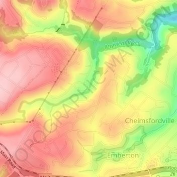
Name: Molweni River topographic map, elevation, terrain.
Average elevation: 603 m
Minimum elevation: 495 m
Maximum elevation: 668 m
Other topographic maps
Click on a map to view its topography, its elevation and its terrain.
Umkomaas
South Africa > KwaZulu-Natal > eThekwini Metropolitan Municipality
The Umkomaas or uMkomazi River is a dominant feature of the area, being the largest river on the South Coast. The river is 298 kilometres long, from its source just south of Giant's Castle in the uKhahlamba / Drakensberg Park World Heritage Site to its mouth on the Indian Ocean. The river begins its journey at…
Average elevation: 38 m
Natal Bay
South Africa > KwaZulu-Natal > eThekwini Metropolitan Municipality > Durban
Average elevation: 4 m
eThekwini Ward 25
South Africa > KwaZulu-Natal > eThekwini Metropolitan Municipality
Average elevation: 72 m
Mpumalanga
South Africa > KwaZulu-Natal > eThekwini Metropolitan Municipality
Average elevation: 582 m
Umhlanga Rocks
South Africa > KwaZulu-Natal > eThekwini Metropolitan Municipality
Average elevation: 45 m
Shongweni Dam
South Africa > KwaZulu-Natal > eThekwini Metropolitan Municipality
Average elevation: 377 m
uMhlangane River
South Africa > KwaZulu-Natal > eThekwini Metropolitan Municipality > KwaMashu
Average elevation: 95 m
eThekwini Ward 97
South Africa > KwaZulu-Natal > eThekwini Metropolitan Municipality
Average elevation: 42 m
eThekwini Ward 99
South Africa > KwaZulu-Natal > eThekwini Metropolitan Municipality
Average elevation: 97 m
Forest Hills
South Africa > KwaZulu-Natal > eThekwini Metropolitan Municipality
Average elevation: 482 m