
Mpumalanga topographic map
Interactive map
Click on the map to display elevation.
About this map
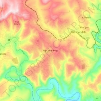
Name: Mpumalanga topographic map, elevation, terrain.
Average elevation: 582 m
Minimum elevation: 347 m
Maximum elevation: 797 m
Other topographic maps
Click on a map to view its topography, its elevation and its terrain.
Umbilo River
South Africa > KwaZulu-Natal > eThekwini Metropolitan Municipality > Durban
Average elevation: 69 m
Umbilo River
South Africa > KwaZulu-Natal > eThekwini Metropolitan Municipality
Average elevation: 372 m
Molweni River
South Africa > KwaZulu-Natal > eThekwini Metropolitan Municipality
Average elevation: 603 m
eThekwini Ward 25
South Africa > KwaZulu-Natal > eThekwini Metropolitan Municipality
Average elevation: 72 m
Blue Lagoon
South Africa > KwaZulu-Natal > eThekwini Metropolitan Municipality > Durban
Average elevation: 16 m
Umgeni River
South Africa > KwaZulu-Natal > eThekwini Metropolitan Municipality > Queensburgh
Average elevation: 149 m
Molweni River
South Africa > KwaZulu-Natal > eThekwini Metropolitan Municipality > Forest Hills
Average elevation: 227 m
Shongweni Dam
South Africa > KwaZulu-Natal > eThekwini Metropolitan Municipality
Average elevation: 377 m
uMhlangane River
South Africa > KwaZulu-Natal > eThekwini Metropolitan Municipality > KwaMashu
Average elevation: 95 m
Umgeni River
South Africa > KwaZulu-Natal > eThekwini Metropolitan Municipality
Average elevation: 342 m
Nkutu River
South Africa > KwaZulu-Natal > eThekwini Metropolitan Municipality > Forest Hills
Average elevation: 448 m
Umgeni River
South Africa > KwaZulu-Natal > eThekwini Metropolitan Municipality > Queensburgh
Average elevation: 155 m
Mhlatuzana River
South Africa > KwaZulu-Natal > eThekwini Metropolitan Municipality > Chatsworth
Average elevation: 136 m
eThekwini Ward 97
South Africa > KwaZulu-Natal > eThekwini Metropolitan Municipality
Average elevation: 42 m
Palmiet River
South Africa > KwaZulu-Natal > eThekwini Metropolitan Municipality > Pinetown
Average elevation: 333 m
uMhlangane River
South Africa > KwaZulu-Natal > eThekwini Metropolitan Municipality > KwaMashu
Average elevation: 65 m
eThekwini Ward 99
South Africa > KwaZulu-Natal > eThekwini Metropolitan Municipality
Average elevation: 97 m
Palmiet River
South Africa > KwaZulu-Natal > eThekwini Metropolitan Municipality > Durban
Average elevation: 72 m
Mahlongwana River
South Africa > KwaZulu-Natal > eThekwini Metropolitan Municipality > Umkomaas
Average elevation: 85 m
Twilight Drive Public Park
South Africa > KwaZulu-Natal > eThekwini Metropolitan Municipality > Umhlanga
Average elevation: 116 m
Bulwer Park
South Africa > KwaZulu-Natal > eThekwini Metropolitan Municipality > Durban
Average elevation: 59 m