
Rivers State topographic map
Interactive map
Click on the map to display elevation.
About this map
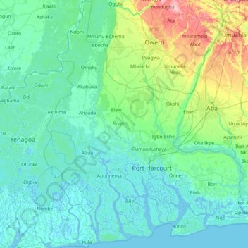
Name: Rivers State topographic map, elevation, terrain.
Location: Rivers State, Nigeria (4.30796 6.39839 5.73029 7.60408)
Average elevation: 29 m
Minimum elevation: -4 m
Maximum elevation: 247 m
Rivers State is a predominantly low-lying pluvial state in southern Nigeria, located in the eastern part of the Niger Delta on the oceanward extension of the Benue Trough. The inland part of the state consists of tropical rainforest, and towards the coast, the typical Niger Delta environment features many mangrove swamps. Rivers State has a total area of 11,077 km2 (4,277 sq mi), making it the 26th largest state in Nigeria. Surrounding states are Imo, Abia and Anambra to the north, Akwa Ibom to the east and Bayelsa, Delta to the west. On the south, it is bounded by the Atlantic Ocean. Its topography ranges from flat plains, with a network of rivers to tributaries.
Other topographic maps
Click on a map to view its topography, its elevation and its terrain.
Mashare
Nigeria > Kano State > Sumaila
Mashare, Gala, Sumaila, Kano State, Nigeria
Average elevation: 462 m
Afriski
Nigeria > Borno State > Marte > Muwalli
Afriski, Muwalli, Marte, Borno State, Nigeria
Average elevation: 291 m
Kwa
Nigeria > Kano State > Dawakin Tofa
Kwa, Dawakin Tofa, Kano State, Nigeria
Average elevation: 494 m
Durba
Nigeria > Kano State > Kibiya > Durba
Durba, Kibiya, Kano State, Nigeria
Average elevation: 479 m
Onitsha
Nigeria > Anambra > Onitsha North > Onitsha
Onitsha, Onitsha North, Anambra, 430231, Nigeria
Average elevation: 71 m
Dumba
Nigeria > Bauchi > Udubo Central > Dumba
Dumba, Udubo Central, Gamawa, Bauchi, Nigeria
Average elevation: 373 m
Federal Capital Territory
Nigeria > Federal Capital Territory
Federal Capital Territory, Nigeria
Average elevation: 337 m
Kainji Reservoir
Kainji Reservoir, Gafara, Ngaski, Kebbi, Nigeria
Average elevation: 137 m
Abuja
Nigeria > Federal Capital Territory > Municipal Area Council > Abuja
Abuja, Municipal Area Council, Federal Capital Territory, 900001, Nigeria
Average elevation: 508 m