
El Asintal topographic map
Interactive map
Click on the map to display elevation.
About this map
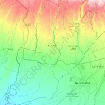
Name: El Asintal topographic map, elevation, terrain.
Location: El Asintal, Retalhuleu, Guatemala (14.50107 -91.80154 14.66731 -91.71381)
Average elevation: 359 m
Minimum elevation: 77 m
Maximum elevation: 893 m
Other topographic maps
Click on a map to view its topography, its elevation and its terrain.
Municipio de Retalhuleu
Municipio de Retalhuleu, Retalhuleu, Guatemala
Average elevation: 139 m
Nuevo San Carlos
Guatemala > Retalhuleu > Nuevo San Carlos
Nuevo San Carlos, Retalhuleu, Guatemala
Average elevation: 356 m
San Felipe
Guatemala > Retalhuleu > San Felipe
San Felipe, Retalhuleu, Guatemala
Average elevation: 736 m
San Andrés Villa Seca
San Andrés Villa Seca, Retalhuleu, Guatemala
Average elevation: 148 m
Santa Cruz Muluá
Guatemala > Retalhuleu > Santa Cruz Muluá
Santa Cruz Muluá, Retalhuleu, Guatemala
Average elevation: 403 m
San Martin Zapotitlan
Guatemala > Retalhuleu > San Martin Zapotitlan
San Martin Zapotitlan, San Martín Zapotitlán, Retalhuleu, Guatemala
Average elevation: 526 m
El Asintal
Guatemala > Retalhuleu > El Asintal
El Asintal, Retalhuleu, Guatemala
Average elevation: 388 m
Champerico
Guatemala > Retalhuleu > Champerico
Champerico, Retalhuleu, Guatemala
Average elevation: 6 m
Río Samalá
Río Samalá, Santa Cruz Muluá, Retalhuleu, Guatemala
Average elevation: 232 m
San Sebastian
Guatemala > Retalhuleu > San Sebastian
San Sebastian, San Sebastián, Retalhuleu, Guatemala
Average elevation: 318 m