
County Carlow topographic map
Interactive map
Click on the map to display elevation.
About this map
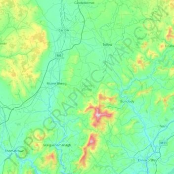
Name: County Carlow topographic map, elevation, terrain.
Location: County Carlow, Leinster, Irland (52.46359 -7.10794 52.91802 -6.50494)
Average elevation: 126 m
Minimum elevation: 0 m
Maximum elevation: 789 m
Other topographic maps
Click on a map to view its topography, its elevation and its terrain.
Carrickmacross-Castleblaney Municipal District
Carrickmacross-Castleblaney Municipal District, County Monaghan, Ulster, Irland
Average elevation: 114 m
Killaloe Municipal District
Killaloe Municipal District, County Clare, Munster, Irland
Average elevation: 85 m
Lear
Lear, Canningstown ED, Bailieborough-Cootehill Municipal District, County Cavan, Ulster, Irland
Average elevation: 189 m
Dunmore East
Dunmore East, County Waterford, Munster, X91 C677, Irland
Average elevation: 36 m
Knockanteedan
Knockanteedan, Glassamucky, Bohernabreena DED 1986, South Dublin, County Dublin, Leinster, D24 T651, Irland
Average elevation: 243 m
Cloncarney
Irland > County Donegal > Letterkenny Municipal District
Cloncarney, Templedouglas ED, Letterkenny Municipal District, County Donegal, Irland
Average elevation: 123 m
Little Sugar Loaf
Little Sugar Loaf, The Municipal District of Bray, County Wicklow, Leinster, A63 FX34, Irland
Average elevation: 131 m
Ballymahon
Ballymahon, Castlerickard ED, The Municipal District of Trim, County Meath, Leinster, Irland
Average elevation: 66 m
Ballykeeran
Ballykeeran, The Municipal District of Athlone — Moate, County Westmeath, Leinster, N37 VK74, Irland
Average elevation: 47 m
Glencolumbkille
Glencolumbkille, County Donegal, Ulster, Irland
Average elevation: 95 m
Glenties Municipal District
Glenties Municipal District, County Donegal, Ulster, Irland
Average elevation: 90 m
Ennis Municipal District
Ennis Municipal District, County Clare, Munster, Irland
Average elevation: 39 m
Swanlinbar
Swanlinbar, Cavan-Belturbet Municipal District, County Cavan, Irland
Average elevation: 97 m
Gubnafarna
Gubnafarna, Kinawley ED, Cavan-Belturbet Municipal District, County Cavan, Irland
Average elevation: 178 m
The Municipal District of Muinebeag
The Municipal District of Muinebeag, County Carlow, Leinster, Irland
Average elevation: 129 m
Naas
Naas, The Municipal District of Naas, County Kildare, Leinster, Irland
Average elevation: 99 m
Goatstown
Goatstown, Dún Laoghaire-Rathdown, County Dublin, Leinster, D14 WR83, Irland
Average elevation: 57 m
Derrycastle
Derrycastle, The Municipal District of Nenagh, County Tipperary, Munster, Irland
Average elevation: 152 m
The Municipal District of Nenagh
The Municipal District of Nenagh, County Tipperary, Munster, Irland
Average elevation: 116 m
Ballybay-Clones Municipal District
Ballybay-Clones Municipal District, County Monaghan, Ulster, Irland
Average elevation: 114 m
The Municipal District of Gorey — Kilmuckridge
The Municipal District of Gorey — Kilmuckridge, County Wexford, Leinster, Irland
Average elevation: 58 m
Curraheen
Curraheen, Glanbehy ED, Kenmare Municipal District, County Kerry, Munster, Irland
Average elevation: 124 m
Balliny South
Balliny South, Derreen ED, West Clare Municipal District, County Clare, Munster, Irland
Average elevation: 253 m
Kenmare Municipal District
Kenmare Municipal District, County Kerry, Munster, Irland
Average elevation: 98 m
Glenmore
Glenmore, Rathcor ED, The Municipal District of Dundalk, County Louth, Leinster, Irland
Average elevation: 241 m
The Municipal District of Baltinglass
The Municipal District of Baltinglass, County Wicklow, Leinster, Irland
Average elevation: 182 m
Ballynabarney
Ballynabarney, Wingfield ED, The Municipal District of Gorey — Kilmuckridge, County Wexford, Leinster, Irland
Average elevation: 241 m
An Coimín Theas
An Coimín Theas, Toghroinn ceantair Dún Chaoin, Kenmare Municipal District, County Kerry, Munster, Irland
Average elevation: 248 m
Abbeyfeale
Irland > County Limerick > The Municipal District of Newcastle West
Abbeyfeale, The Municipal District of Newcastle West, County Limerick, Munster, Irland
Average elevation: 150 m
The Municipal District of Kanturk – Mallow
The Municipal District of Kanturk – Mallow, County Cork, Munster, Irland
Average elevation: 182 m
Bridgetown
Bridgetown, Clonea, The Municipal District of Comeragh, County Waterford, Munster, Irland
Average elevation: 89 m
Slieve League
Slieve League, Donegal Municipal District, County Donegal, Irland
Average elevation: 233 m
Tuam Municipal District
Tuam Municipal District, County Galway, Connacht, Irland
Average elevation: 54 m
Arless ED
Arless ED, The Municipal District of Graiguecullen — Portarlington, County Laois, Leinster, Irland
Average elevation: 97 m
Tullagreen
Irland > County Cork > Municipal District of Cobh
Tullagreen, Carrigtohill ED, Municipal District of Cobh, County Cork, Munster, Irland
Average elevation: 12 m
Loughrea Municipal District
Loughrea Municipal District, County Galway, Connacht, Irland
Average elevation: 69 m
The Municipal District of Navan
The Municipal District of Navan, County Meath, Leinster, Irland
Average elevation: 62 m
Brandon Hill
Brandon Hill, The Municipal District of Callan — Thomastown, County Kilkenny, Leinster, R95 EKN5, Irland
Average elevation: 294 m
Garvagh/Arigna ED
Garvagh/Arigna ED, Manorhamilton Municipal District, County Leitrim, Connacht, Irland
Average elevation: 201 m
Westport-Belmullet Municipal District
Westport-Belmullet Municipal District, County Mayo, Connacht, Irland
Average elevation: 62 m
Scarriff
Irland > County Clare > Scarriff
Scarriff, Killaloe Municipal District, County Clare, Munster, Irland
Average elevation: 52 m
Ennistymon
Ennistymon, West Clare Municipal District, County Clare, Munster, Irland
Average elevation: 61 m
Mountshannon
Irland > County Clare > Mountshannon
Mountshannon, Killaloe Municipal District, County Clare, Munster, Irland
Average elevation: 52 m
Borrisoleigh
Irland > County Tipperary > Borrisoleigh
Borrisoleigh, The Municipal District of Thurles, County Tipperary, Munster, Irland
Average elevation: 128 m