
Blyderivierpoort Dam topographic map
Interactive map
Click on the map to display elevation.
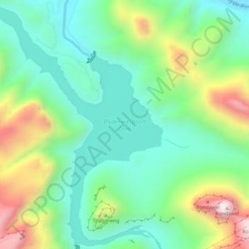
Blyderivierpoort Dam topographic map, elevation, terrain
About this map
Name: Blyderivierpoort Dam topographic map, elevation, terrain.
Average elevation: 835 m
Minimum elevation: 581 m
Maximum elevation: 1,370 m
Other topographic maps
Click on a map to view its topography, its elevation and its terrain.
Lowveld View
South Africa > Mpumalanga > Ehlanzeni District Municipality > Thaba Chweu Local Municipality > Frankfurt
Average elevation: 1,104 m
Thaba Chweu Ward 13
South Africa > Mpumalanga > Ehlanzeni District Municipality > Thaba Chweu Local Municipality
Average elevation: 1,458 m
Khutsong
South Africa > Mpumalanga > Ehlanzeni District Municipality > Thaba Chweu Local Municipality
Average elevation: 1,288 m
Lydenburg
South Africa > Mpumalanga > Ehlanzeni District Municipality > Thaba Chweu Local Municipality
Average elevation: 1,424 m
Mashishing
South Africa > Mpumalanga > Ehlanzeni District Municipality > Thaba Chweu Local Municipality
Average elevation: 1,421 m
Blyde River Canyon Nature Reserve
South Africa > Mpumalanga > Ehlanzeni District Municipality > Thaba Chweu Local Municipality
The Mogologolo (1,794 m), Mariepskop (1,944 m) and Hebronberg (1,767 m) massifs are partially included in the reserve. Elevation varies from 560 m to 1,944 m above sea level. Its resort areas are F.H. Odendaal and Swadeni, the latter only accessible from Limpopo province. The area of approximately 29,000…
Average elevation: 1,040 m
Sabie
South Africa > Mpumalanga > Ehlanzeni District Municipality > Thaba Chweu Local Municipality
Average elevation: 1,150 m
Pilgrim's Rest
South Africa > Mpumalanga > Ehlanzeni District Municipality > Thaba Chweu Local Municipality
Average elevation: 1,352 m
Mount Anderson
South Africa > Mpumalanga > Ehlanzeni District Municipality > Thaba Chweu Local Municipality > Mount Anderson
Average elevation: 1,173 m
Apara
South Africa > Mpumalanga > Ehlanzeni District Municipality > Thaba Chweu Local Municipality > Apara
Average elevation: 1,204 m
Kanana
South Africa > Mpumalanga > Ehlanzeni District Municipality > Thaba Chweu Local Municipality
Average elevation: 1,273 m